You are here: Home > Network List > BK - Berkeley Digital Seismograph Network Stations List
> Station CMB Columbia College, California, USA > Earthquake Result Viewer
CMB Columbia College, California, USA - Earthquake Result Viewer
| Earthquake location: |
Fiji Islands Region |
| Earthquake latitude/longitude: |
-14.3/-178.3 |
| Earthquake time(UTC): |
1993/03/12 (071) 14:01:38 GMT |
| Earthquake Depth: |
33 km |
| Earthquake Magnitude: |
5.9 MB, 6.5 MS |
| Earthquake Catalog/Contributor: |
WHDF/NEIC |
|
| Network: |
BK Berkeley Digital Seismograph Network |
| Station: |
CMB Columbia College, California, USA |
| Lat/Lon: |
38.03 N/120.39 W |
| Elevation: |
719 m |
|
| Distance: |
75.2 deg |
| Az: |
43.786 deg |
| Baz: |
238.139 deg |
| Ray Param: |
0.051782113 |
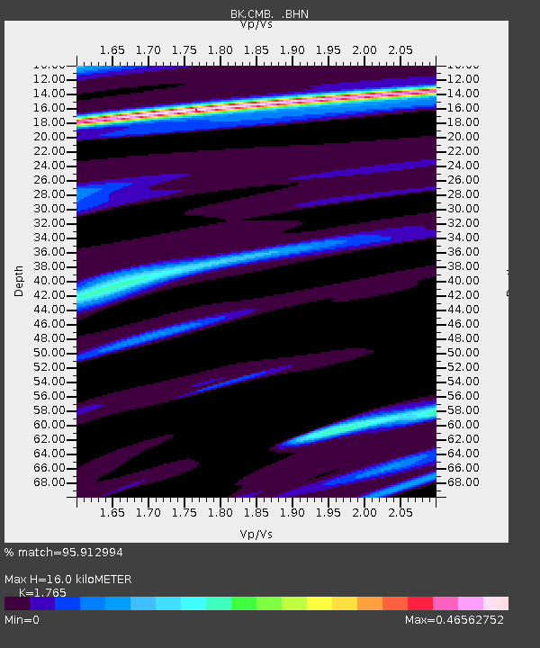
| Estimated Moho Depth: |
16.0 km |
| Estimated Crust Vp/Vs: |
1.76 |
| Assumed Crust Vp: |
6.597 km/s |
| Estimated Crust Vs: |
3.738 km/s |
| Estimated Crust Poisson's Ratio: |
0.26 |
|
| Radial Match: |
95.912994 % |
| Radial Bump: |
289 |
| Transverse Match: |
83.7672 % |
| Transverse Bump: |
378 |
| SOD ConfigId: |
16938 |
| Insert Time: |
2010-03-05 18:40:15.528 +0000 |
| GWidth: |
2.5 |
| Max Bumps: |
400 |
| Tol: |
0.001 |
|
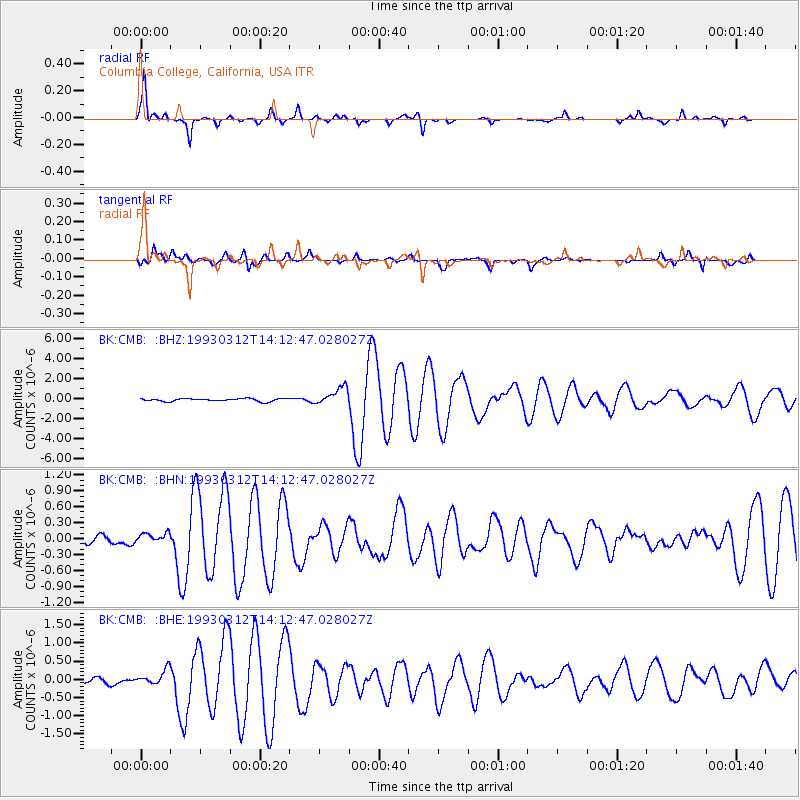
Signal To Noise
| Channel | StoN | STA | LTA |
| BK:CMB: :BHN:19930312T14:12:47.028027Z | 1.5121149 | 9.60719E-8 | 6.3534785E-8 |
| BK:CMB: :BHE:19930312T14:12:47.028027Z | 3.3637872 | 2.0619309E-7 | 6.12979E-8 |
| BK:CMB: :BHZ:19930312T14:12:47.028027Z | 6.1472664 | 8.659746E-7 | 1.4087149E-7 |
| Arrivals |
| Ps | 1.9 SECOND |
| PpPs | 6.5 SECOND |
| PsPs/PpSs | 8.4 SECOND |


