You are here: Home > Network List > TA - USArray Transportable Network (new EarthScope stations) Stations List
> Station F21K Alatna River, AK, USA > Earthquake Result Viewer
F21K Alatna River, AK, USA - Earthquake Result Viewer
| Earthquake location: |
New Britain Region, P.N.G. |
| Earthquake latitude/longitude: |
-4.3/150.4 |
| Earthquake time(UTC): |
2016/10/15 (289) 08:03:39 GMT |
| Earthquake Depth: |
451 km |
| Earthquake Magnitude: |
6.0 MB |
| Earthquake Catalog/Contributor: |
NEIC PDE/NEIC ALERT |
|
| Network: |
TA USArray Transportable Network (new EarthScope stations) |
| Station: |
F21K Alatna River, AK, USA |
| Lat/Lon: |
67.22 N/153.48 W |
| Elevation: |
597 m |
|
| Distance: |
81.5 deg |
| Az: |
19.077 deg |
| Baz: |
236.834 deg |
| Ray Param: |
0.04629422 |
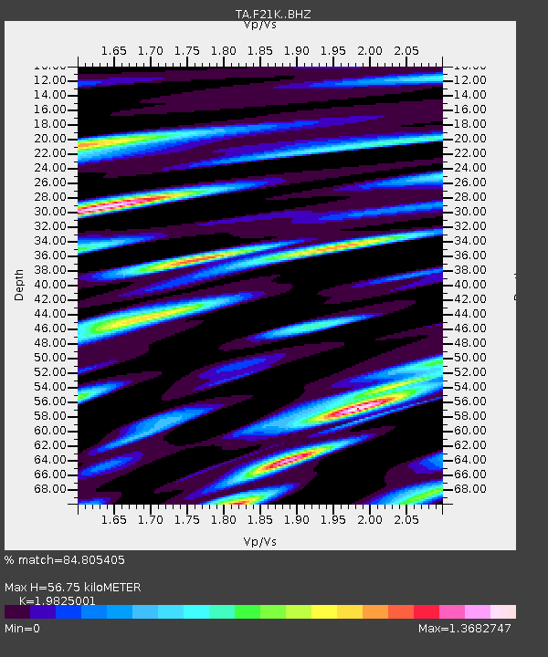
| Estimated Moho Depth: |
56.75 km |
| Estimated Crust Vp/Vs: |
1.98 |
| Assumed Crust Vp: |
6.455 km/s |
| Estimated Crust Vs: |
3.256 km/s |
| Estimated Crust Poisson's Ratio: |
0.33 |
|
| Radial Match: |
84.805405 % |
| Radial Bump: |
400 |
| Transverse Match: |
78.414215 % |
| Transverse Bump: |
400 |
| SOD ConfigId: |
11737051 |
| Insert Time: |
2019-04-25 18:07:57.037 +0000 |
| GWidth: |
2.5 |
| Max Bumps: |
400 |
| Tol: |
0.001 |
|
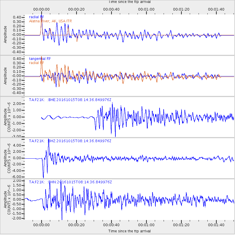
Signal To Noise
| Channel | StoN | STA | LTA |
| TA:F21K: :BHZ:20161015T08:14:36.849976Z | 36.441032 | 2.6989053E-6 | 7.4062264E-8 |
| TA:F21K: :BHN:20161015T08:14:36.849976Z | 6.9267893 | 7.236472E-7 | 1.0447079E-7 |
| TA:F21K: :BHE:20161015T08:14:36.849976Z | 7.123459 | 8.995638E-7 | 1.2628189E-7 |
| Arrivals |
| Ps | 8.8 SECOND |
| PpPs | 26 SECOND |
| PsPs/PpSs | 34 SECOND |


