You are here: Home > Network List > TA - USArray Transportable Network (new EarthScope stations) Stations List
> Station F25K Christian River, AK, USA > Earthquake Result Viewer
F25K Christian River, AK, USA - Earthquake Result Viewer
| Earthquake location: |
New Britain Region, P.N.G. |
| Earthquake latitude/longitude: |
-4.3/150.4 |
| Earthquake time(UTC): |
2016/10/15 (289) 08:03:39 GMT |
| Earthquake Depth: |
451 km |
| Earthquake Magnitude: |
6.0 MB |
| Earthquake Catalog/Contributor: |
NEIC PDE/NEIC ALERT |
|
| Network: |
TA USArray Transportable Network (new EarthScope stations) |
| Station: |
F25K Christian River, AK, USA |
| Lat/Lon: |
67.59 N/145.64 W |
| Elevation: |
864 m |
|
| Distance: |
84.3 deg |
| Az: |
20.251 deg |
| Baz: |
244.212 deg |
| Ray Param: |
0.04435064 |
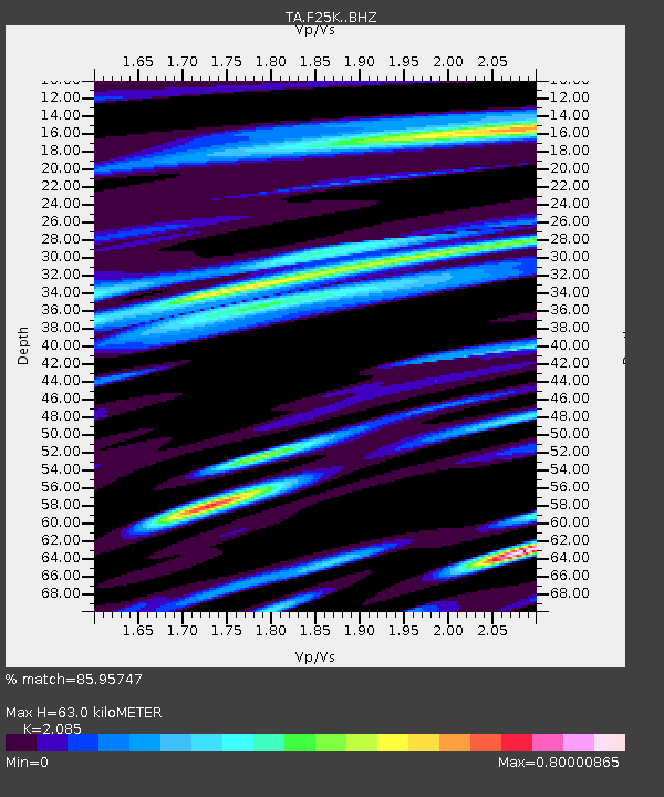
| Estimated Moho Depth: |
63.0 km |
| Estimated Crust Vp/Vs: |
2.09 |
| Assumed Crust Vp: |
6.522 km/s |
| Estimated Crust Vs: |
3.128 km/s |
| Estimated Crust Poisson's Ratio: |
0.35 |
|
| Radial Match: |
85.95747 % |
| Radial Bump: |
400 |
| Transverse Match: |
73.935455 % |
| Transverse Bump: |
400 |
| SOD ConfigId: |
11737051 |
| Insert Time: |
2019-04-25 18:08:00.862 +0000 |
| GWidth: |
2.5 |
| Max Bumps: |
400 |
| Tol: |
0.001 |
|

Signal To Noise
| Channel | StoN | STA | LTA |
| TA:F25K: :BHZ:20161015T08:14:51.025024Z | 13.700053 | 2.512571E-6 | 1.8339864E-7 |
| TA:F25K: :BHN:20161015T08:14:51.025024Z | 2.2812626 | 4.616848E-7 | 2.0238127E-7 |
| TA:F25K: :BHE:20161015T08:14:51.025024Z | 8.018855 | 8.666037E-7 | 1.0807075E-7 |
| Arrivals |
| Ps | 11 SECOND |
| PpPs | 29 SECOND |
| PsPs/PpSs | 40 SECOND |


