You are here: Home > Network List > TA - USArray Transportable Network (new EarthScope stations) Stations List
> Station G26K Porcupine River, AK, USA > Earthquake Result Viewer
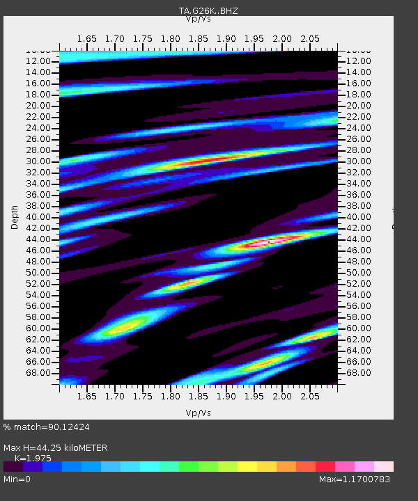
G26K Porcupine River, AK, USA - Earthquake Result Viewer
| Earthquake location: |
New Britain Region, P.N.G. |
| Earthquake latitude/longitude: |
-4.3/150.4 |
| Earthquake time(UTC): |
2016/10/15 (289) 08:03:39 GMT |
| Earthquake Depth: |
451 km |
| Earthquake Magnitude: |
6.0 MB |
| Earthquake Catalog/Contributor: |
NEIC PDE/NEIC ALERT |
|
| Network: |
TA USArray Transportable Network (new EarthScope stations) |
| Station: |
G26K Porcupine River, AK, USA |
| Lat/Lon: |
66.95 N/143.78 W |
| Elevation: |
180 m |
|
| Distance: |
84.7 deg |
| Az: |
21.146 deg |
| Baz: |
246.011 deg |
| Ray Param: |
0.0440876 |
| Estimated Moho Depth: |
44.25 km |
| Estimated Crust Vp/Vs: |
1.98 |
| Assumed Crust Vp: |
6.577 km/s |
| Estimated Crust Vs: |
3.33 km/s |
| Estimated Crust Poisson's Ratio: |
0.33 |
|
| Radial Match: |
90.12424 % |
| Radial Bump: |
400 |
| Transverse Match: |
88.083595 % |
| Transverse Bump: |
400 |
| SOD ConfigId: |
11737051 |
| Insert Time: |
2019-04-25 18:08:05.999 +0000 |
| GWidth: |
2.5 |
| Max Bumps: |
400 |
| Tol: |
0.001 |
|

Signal To Noise
| Channel | StoN | STA | LTA |
| TA:G26K: :BHZ:20161015T08:14:52.924988Z | 38.19627 | 6.560524E-6 | 1.7175823E-7 |
| TA:G26K: :BHN:20161015T08:14:52.924988Z | 16.710537 | 2.3170126E-6 | 1.3865578E-7 |
| TA:G26K: :BHE:20161015T08:14:52.924988Z | 14.572484 | 1.9551605E-6 | 1.3416796E-7 |
| Arrivals |
| Ps | 6.7 SECOND |
| PpPs | 20 SECOND |
| PsPs/PpSs | 26 SECOND |


