You are here: Home > Network List > TA - USArray Transportable Network (new EarthScope stations) Stations List
> Station J29M Klondike Camp, Yukon, CA > Earthquake Result Viewer
J29M Klondike Camp, Yukon, CA - Earthquake Result Viewer
| Earthquake location: |
New Britain Region, P.N.G. |
| Earthquake latitude/longitude: |
-4.3/150.4 |
| Earthquake time(UTC): |
2016/10/15 (289) 08:03:39 GMT |
| Earthquake Depth: |
451 km |
| Earthquake Magnitude: |
6.0 MB |
| Earthquake Catalog/Contributor: |
NEIC PDE/NEIC ALERT |
|
| Network: |
TA USArray Transportable Network (new EarthScope stations) |
| Station: |
J29M Klondike Camp, Yukon, CA |
| Lat/Lon: |
64.45 N/138.22 W |
| Elevation: |
982 m |
|
| Distance: |
85.9 deg |
| Az: |
24.328 deg |
| Baz: |
251.344 deg |
| Ray Param: |
0.04322165 |
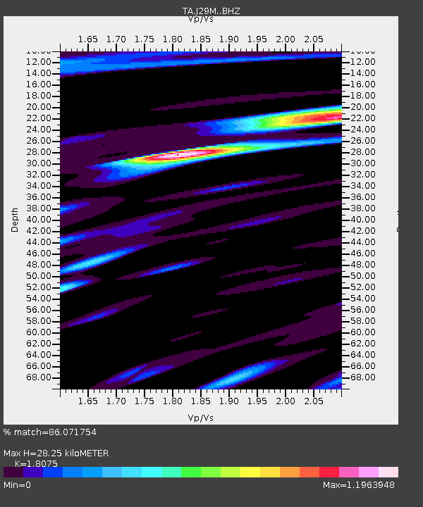
| Estimated Moho Depth: |
28.25 km |
| Estimated Crust Vp/Vs: |
1.81 |
| Assumed Crust Vp: |
6.566 km/s |
| Estimated Crust Vs: |
3.633 km/s |
| Estimated Crust Poisson's Ratio: |
0.28 |
|
| Radial Match: |
86.071754 % |
| Radial Bump: |
400 |
| Transverse Match: |
86.30815 % |
| Transverse Bump: |
400 |
| SOD ConfigId: |
11737051 |
| Insert Time: |
2019-04-25 18:08:30.710 +0000 |
| GWidth: |
2.5 |
| Max Bumps: |
400 |
| Tol: |
0.001 |
|

Signal To Noise
| Channel | StoN | STA | LTA |
| TA:J29M: :BHZ:20161015T08:14:58.924988Z | 30.061731 | 5.9007334E-6 | 1.9628722E-7 |
| TA:J29M: :BHN:20161015T08:14:58.924988Z | 16.804115 | 3.853834E-6 | 2.2933872E-7 |
| TA:J29M: :BHE:20161015T08:14:58.924988Z | 18.104494 | 4.5930406E-6 | 2.5369616E-7 |
| Arrivals |
| Ps | 3.6 SECOND |
| PpPs | 12 SECOND |
| PsPs/PpSs | 15 SECOND |


