You are here: Home > Network List > YT07 - POLENET Stations List
> Station MPAT MPAT > Earthquake Result Viewer
MPAT MPAT - Earthquake Result Viewer
| Earthquake location: |
New Britain Region, P.N.G. |
| Earthquake latitude/longitude: |
-4.3/150.4 |
| Earthquake time(UTC): |
2016/10/15 (289) 08:03:39 GMT |
| Earthquake Depth: |
451 km |
| Earthquake Magnitude: |
6.0 MB |
| Earthquake Catalog/Contributor: |
NEIC PDE/NEIC ALERT |
|
| Network: |
YT POLENET |
| Station: |
MPAT MPAT |
| Lat/Lon: |
78.03 S/155.02 W |
| Elevation: |
540 m |
|
| Distance: |
78.9 deg |
| Az: |
170.018 deg |
| Baz: |
304.09 deg |
| Ray Param: |
0.048045956 |
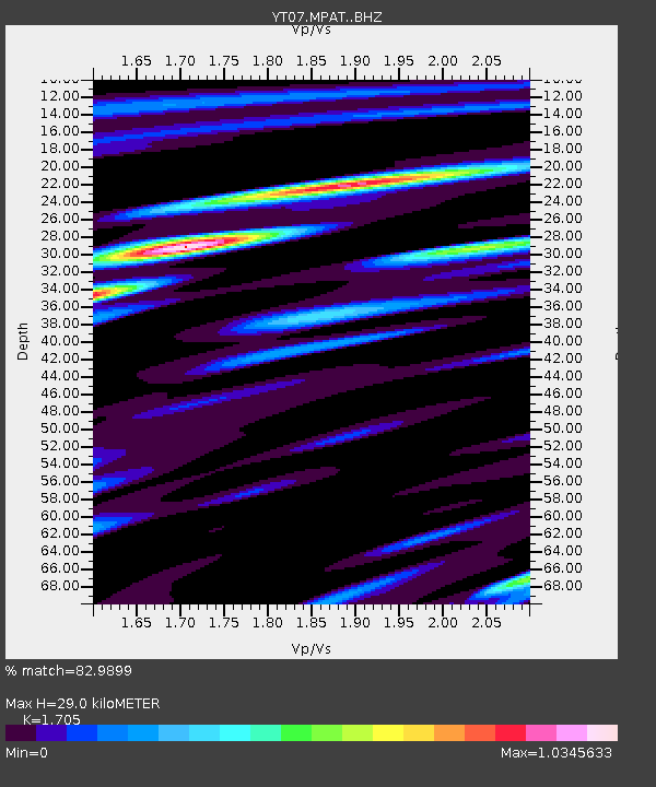
| Estimated Moho Depth: |
29.0 km |
| Estimated Crust Vp/Vs: |
1.71 |
| Assumed Crust Vp: |
6.43 km/s |
| Estimated Crust Vs: |
3.771 km/s |
| Estimated Crust Poisson's Ratio: |
0.24 |
|
| Radial Match: |
82.9899 % |
| Radial Bump: |
366 |
| Transverse Match: |
72.27767 % |
| Transverse Bump: |
400 |
| SOD ConfigId: |
11737051 |
| Insert Time: |
2019-04-25 18:13:05.484 +0000 |
| GWidth: |
2.5 |
| Max Bumps: |
400 |
| Tol: |
0.001 |
|

Signal To Noise
| Channel | StoN | STA | LTA |
| YT:MPAT: :BHZ:20161015T08:14:23.224976Z | 11.177607 | 9.991774E-7 | 8.939099E-8 |
| YT:MPAT: :BHN:20161015T08:14:23.224976Z | 3.98804 | 1.6132472E-7 | 4.0452136E-8 |
| YT:MPAT: :BHE:20161015T08:14:23.224976Z | 7.700482 | 3.7966038E-7 | 4.930346E-8 |
| Arrivals |
| Ps | 3.3 SECOND |
| PpPs | 12 SECOND |
| PsPs/PpSs | 15 SECOND |


