You are here: Home > Network List > LD - Lamont-Doherty Cooperative Seismographic Network Stations List
> Station TUPA Temple University, Pennsylvania > Earthquake Result Viewer
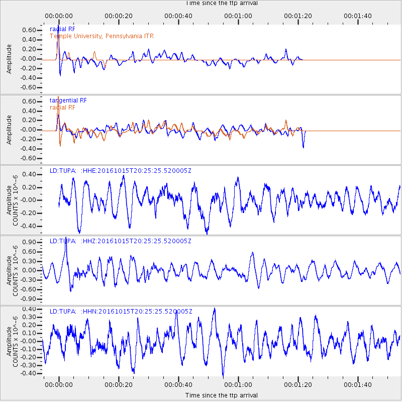
TUPA Temple University, Pennsylvania - Earthquake Result Viewer
*The percent match for this event was below the threshold and hence no stack was calculated.
| Earthquake location: |
Greece-Albania Border Region |
| Earthquake latitude/longitude: |
39.8/20.7 |
| Earthquake time(UTC): |
2016/10/15 (289) 20:14:49 GMT |
| Earthquake Depth: |
22 km |
| Earthquake Magnitude: |
5.5 MWW, 5.3 MWB, 5.5 MWC |
| Earthquake Catalog/Contributor: |
NEIC PDE/NEIC COMCAT |
|
| Network: |
LD Lamont-Doherty Cooperative Seismographic Network |
| Station: |
TUPA Temple University, Pennsylvania |
| Lat/Lon: |
40.17 N/75.19 W |
| Elevation: |
112 m |
|
| Distance: |
69.5 deg |
| Az: |
305.543 deg |
| Baz: |
54.873 deg |
| Ray Param: |
$rayparam |
*The percent match for this event was below the threshold and hence was not used in the summary stack. |
|
| Radial Match: |
55.826584 % |
| Radial Bump: |
400 |
| Transverse Match: |
54.187344 % |
| Transverse Bump: |
400 |
| SOD ConfigId: |
11737051 |
| Insert Time: |
2019-04-25 18:26:04.939 +0000 |
| GWidth: |
2.5 |
| Max Bumps: |
400 |
| Tol: |
0.001 |
|
Signal To Noise
| Channel | StoN | STA | LTA |
| LD:TUPA: :HHZ:20161015T20:25:25.520005Z | 1.9839742 | 4.458878E-7 | 2.2474477E-7 |
| LD:TUPA: :HHN:20161015T20:25:25.520005Z | 0.6852205 | 1.1810873E-7 | 1.7236601E-7 |
| LD:TUPA: :HHE:20161015T20:25:25.520005Z | 0.56393105 | 1.17887126E-7 | 2.0904528E-7 |
| Arrivals |
| Ps | |
| PpPs | |
| PsPs/PpSs | |


