You are here: Home > Network List > BK - Berkeley Digital Seismograph Network Stations List
> Station CMB Columbia College, California, USA > Earthquake Result Viewer
CMB Columbia College, California, USA - Earthquake Result Viewer
| Earthquake location: |
Kuril Islands |
| Earthquake latitude/longitude: |
43.9/147.9 |
| Earthquake time(UTC): |
1994/10/09 (282) 07:55:38 GMT |
| Earthquake Depth: |
23 km |
| Earthquake Magnitude: |
6.5 MB, 7.0 MS, 6.7 UNKNOWN, 7.3 MW |
| Earthquake Catalog/Contributor: |
WHDF/NEIC |
|
| Network: |
BK Berkeley Digital Seismograph Network |
| Station: |
CMB Columbia College, California, USA |
| Lat/Lon: |
38.03 N/120.39 W |
| Elevation: |
719 m |
|
| Distance: |
66.0 deg |
| Az: |
59.776 deg |
| Baz: |
307.719 deg |
| Ray Param: |
0.057882406 |
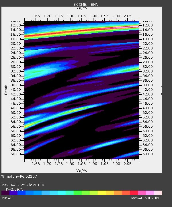
| Estimated Moho Depth: |
12.25 km |
| Estimated Crust Vp/Vs: |
2.10 |
| Assumed Crust Vp: |
6.597 km/s |
| Estimated Crust Vs: |
3.145 km/s |
| Estimated Crust Poisson's Ratio: |
0.35 |
|
| Radial Match: |
96.02207 % |
| Radial Bump: |
399 |
| Transverse Match: |
92.89139 % |
| Transverse Bump: |
400 |
| SOD ConfigId: |
17000 |
| Insert Time: |
2010-03-05 18:42:14.515 +0000 |
| GWidth: |
2.5 |
| Max Bumps: |
400 |
| Tol: |
0.001 |
|

Signal To Noise
| Channel | StoN | STA | LTA |
| BK:CMB: :BHN:19941009T08:05:51.364014Z | 3.2632146 | 1.4391742E-7 | 4.410296E-8 |
| BK:CMB: :BHE:19941009T08:05:51.364014Z | 2.817438 | 1.0109285E-7 | 3.588113E-8 |
| BK:CMB: :BHZ:19941009T08:05:51.364014Z | 7.3586626 | 3.9404262E-7 | 5.354813E-8 |
| Arrivals |
| Ps | 2.1 SECOND |
| PpPs | 5.5 SECOND |
| PsPs/PpSs | 7.7 SECOND |


