You are here: Home > Network List > TJ - Tajikistan National Seismic Network Stations List
> Station CHGR Chuyangaron, Tajikistan > Earthquake Result Viewer
CHGR Chuyangaron, Tajikistan - Earthquake Result Viewer
| Earthquake location: |
Greece-Albania Border Region |
| Earthquake latitude/longitude: |
39.8/20.7 |
| Earthquake time(UTC): |
2016/10/15 (289) 20:14:49 GMT |
| Earthquake Depth: |
22 km |
| Earthquake Magnitude: |
5.5 MWW, 5.3 MWB, 5.5 MWC |
| Earthquake Catalog/Contributor: |
NEIC PDE/NEIC COMCAT |
|
| Network: |
TJ Tajikistan National Seismic Network |
| Station: |
CHGR Chuyangaron, Tajikistan |
| Lat/Lon: |
38.66 N/69.16 E |
| Elevation: |
1049 m |
|
| Distance: |
37.2 deg |
| Az: |
75.804 deg |
| Baz: |
287.491 deg |
| Ray Param: |
0.07622641 |
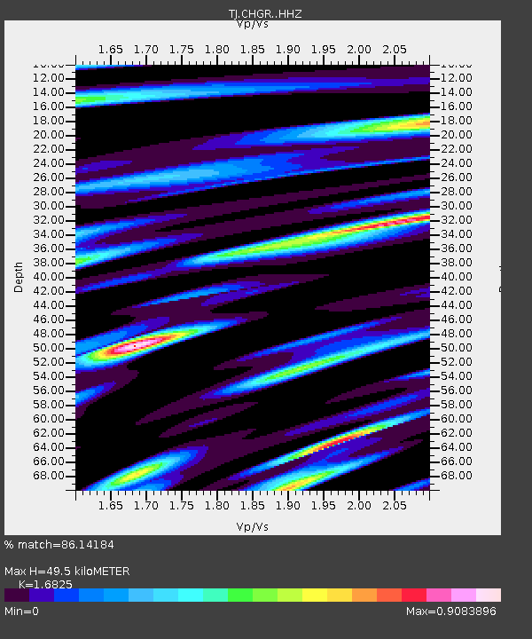
| Estimated Moho Depth: |
49.5 km |
| Estimated Crust Vp/Vs: |
1.68 |
| Assumed Crust Vp: |
6.483 km/s |
| Estimated Crust Vs: |
3.853 km/s |
| Estimated Crust Poisson's Ratio: |
0.23 |
|
| Radial Match: |
86.14184 % |
| Radial Bump: |
400 |
| Transverse Match: |
85.02314 % |
| Transverse Bump: |
400 |
| SOD ConfigId: |
11737051 |
| Insert Time: |
2019-04-25 18:33:30.623 +0000 |
| GWidth: |
2.5 |
| Max Bumps: |
400 |
| Tol: |
0.001 |
|

Signal To Noise
| Channel | StoN | STA | LTA |
| TJ:CHGR: :HHZ:20161015T20:21:28.800004Z | 7.85396 | 9.744354E-7 | 1.240693E-7 |
| TJ:CHGR: :HHN:20161015T20:21:28.800004Z | 2.8070986 | 1.7667537E-7 | 6.293878E-8 |
| TJ:CHGR: :HHE:20161015T20:21:28.800004Z | 7.570996 | 5.984204E-7 | 7.904117E-8 |
| Arrivals |
| Ps | 5.6 SECOND |
| PpPs | 19 SECOND |
| PsPs/PpSs | 25 SECOND |


