You are here: Home > Network List > AK - Alaska Regional Network Stations List
> Station LOGN Logan Glacier, AK, USA > Earthquake Result Viewer
LOGN Logan Glacier, AK, USA - Earthquake Result Viewer
| Earthquake location: |
New Britain Region, P.N.G. |
| Earthquake latitude/longitude: |
-6.1/148.9 |
| Earthquake time(UTC): |
2016/10/17 (291) 06:14:58 GMT |
| Earthquake Depth: |
35 km |
| Earthquake Magnitude: |
6.9 MO |
| Earthquake Catalog/Contributor: |
NEIC PDE/NEIC ALERT |
|
| Network: |
AK Alaska Regional Network |
| Station: |
LOGN Logan Glacier, AK, USA |
| Lat/Lon: |
60.82 N/141.00 W |
| Elevation: |
1665 m |
|
| Distance: |
85.7 deg |
| Az: |
27.523 deg |
| Baz: |
249.703 deg |
| Ray Param: |
0.044501264 |
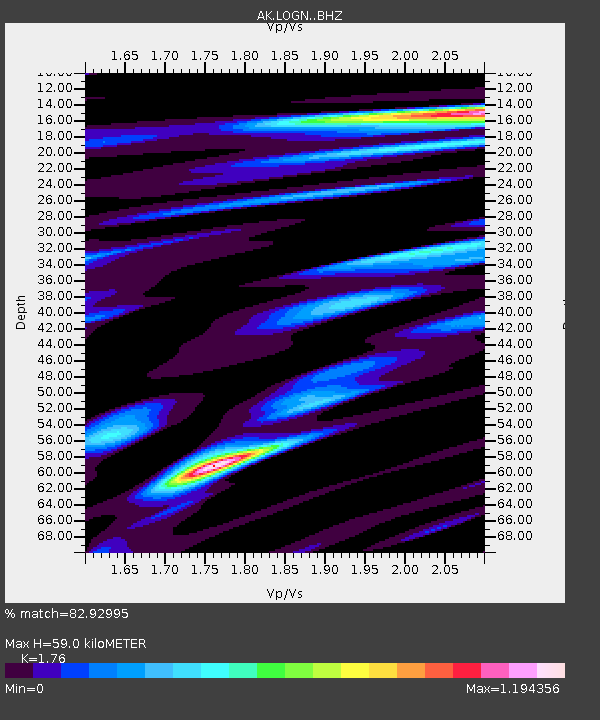
| Estimated Moho Depth: |
59.0 km |
| Estimated Crust Vp/Vs: |
1.76 |
| Assumed Crust Vp: |
6.566 km/s |
| Estimated Crust Vs: |
3.731 km/s |
| Estimated Crust Poisson's Ratio: |
0.26 |
|
| Radial Match: |
82.92995 % |
| Radial Bump: |
400 |
| Transverse Match: |
49.436375 % |
| Transverse Bump: |
400 |
| SOD ConfigId: |
11737051 |
| Insert Time: |
2019-04-25 18:40:59.154 +0000 |
| GWidth: |
2.5 |
| Max Bumps: |
400 |
| Tol: |
0.001 |
|

Signal To Noise
| Channel | StoN | STA | LTA |
| AK:LOGN: :BHZ:20161017T06:27:02.66803Z | 6.423092 | 2.7197857E-6 | 4.2343873E-7 |
| AK:LOGN: :BHN:20161017T06:27:02.66803Z | 3.274974 | 1.0493337E-6 | 3.2040978E-7 |
| AK:LOGN: :BHE:20161017T06:27:02.66803Z | 3.7652657 | 8.887836E-7 | 2.3604802E-7 |
| Arrivals |
| Ps | 7.0 SECOND |
| PpPs | 24 SECOND |
| PsPs/PpSs | 31 SECOND |


