You are here: Home > Network List > BK - Berkeley Digital Seismograph Network Stations List
> Station CMB Columbia College, California, USA > Earthquake Result Viewer
CMB Columbia College, California, USA - Earthquake Result Viewer
| Earthquake location: |
Easter Island Region |
| Earthquake latitude/longitude: |
-22.1/-113.4 |
| Earthquake time(UTC): |
1996/09/05 (249) 08:14:14 GMT |
| Earthquake Depth: |
10 km |
| Earthquake Magnitude: |
6.2 MB, 7.0 MS, 7.0 UNKNOWN, 6.9 MW |
| Earthquake Catalog/Contributor: |
WHDF/NEIC |
|
| Network: |
BK Berkeley Digital Seismograph Network |
| Station: |
CMB Columbia College, California, USA |
| Lat/Lon: |
38.03 N/120.39 W |
| Elevation: |
719 m |
|
| Distance: |
60.2 deg |
| Az: |
353.679 deg |
| Baz: |
172.571 deg |
| Ray Param: |
0.06169734 |
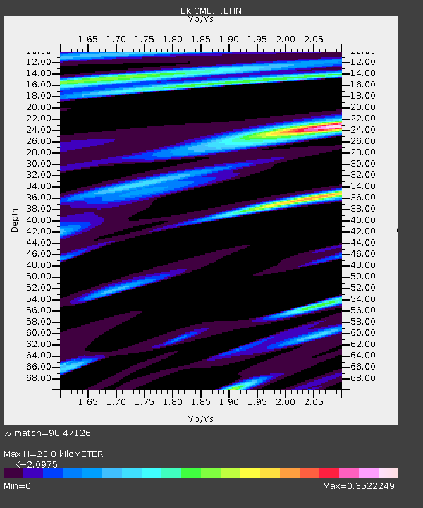
| Estimated Moho Depth: |
23.0 km |
| Estimated Crust Vp/Vs: |
2.10 |
| Assumed Crust Vp: |
6.597 km/s |
| Estimated Crust Vs: |
3.145 km/s |
| Estimated Crust Poisson's Ratio: |
0.35 |
|
| Radial Match: |
98.47126 % |
| Radial Bump: |
257 |
| Transverse Match: |
93.61792 % |
| Transverse Bump: |
400 |
| SOD ConfigId: |
124340 |
| Insert Time: |
2010-03-05 18:43:25.192 +0000 |
| GWidth: |
2.5 |
| Max Bumps: |
400 |
| Tol: |
0.001 |
|
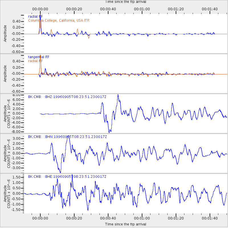
Signal To Noise
| Channel | StoN | STA | LTA |
| BK:CMB: :BHN:19960905T08:23:51.230017Z | 1.3383629 | 8.631814E-8 | 6.449532E-8 |
| BK:CMB: :BHE:19960905T08:23:51.230017Z | 1.0156628 | 7.5056334E-8 | 7.3898875E-8 |
| BK:CMB: :BHZ:19960905T08:23:51.230017Z | 2.748663 | 2.0741724E-7 | 7.5461145E-8 |
| Arrivals |
| Ps | 4.0 SECOND |
| PpPs | 10 SECOND |
| PsPs/PpSs | 14 SECOND |


