You are here: Home > Network List > AV - Alaska Volcano Observatory Stations List
> Station AMKA Regional Station, Amchitka Island, Alaska > Earthquake Result Viewer
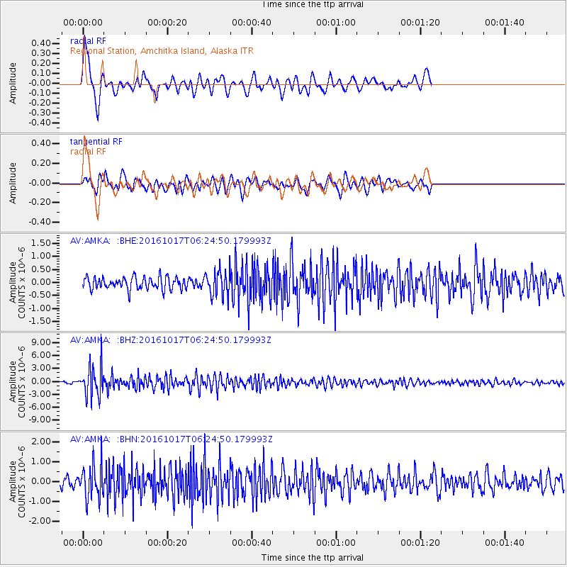
AMKA Regional Station, Amchitka Island, Alaska - Earthquake Result Viewer
*The percent match for this event was below the threshold and hence no stack was calculated.
| Earthquake location: |
New Britain Region, P.N.G. |
| Earthquake latitude/longitude: |
-6.1/148.9 |
| Earthquake time(UTC): |
2016/10/17 (291) 06:14:58 GMT |
| Earthquake Depth: |
35 km |
| Earthquake Magnitude: |
6.9 MO |
| Earthquake Catalog/Contributor: |
NEIC PDE/NEIC ALERT |
|
| Network: |
AV Alaska Volcano Observatory |
| Station: |
AMKA Regional Station, Amchitka Island, Alaska |
| Lat/Lon: |
51.38 N/179.30 E |
| Elevation: |
116 m |
|
| Distance: |
62.9 deg |
| Az: |
20.899 deg |
| Baz: |
214.476 deg |
| Ray Param: |
$rayparam |
*The percent match for this event was below the threshold and hence was not used in the summary stack. |
|
| Radial Match: |
78.75563 % |
| Radial Bump: |
400 |
| Transverse Match: |
69.83452 % |
| Transverse Bump: |
400 |
| SOD ConfigId: |
11737051 |
| Insert Time: |
2019-04-25 18:42:09.519 +0000 |
| GWidth: |
2.5 |
| Max Bumps: |
400 |
| Tol: |
0.001 |
|
Signal To Noise
| Channel | StoN | STA | LTA |
| AV:AMKA: :BHZ:20161017T06:24:50.179993Z | 15.667278 | 3.4837644E-6 | 2.2235926E-7 |
| AV:AMKA: :BHN:20161017T06:24:50.179993Z | 3.8267066 | 8.5185064E-7 | 2.2260673E-7 |
| AV:AMKA: :BHE:20161017T06:24:50.179993Z | 1.9865456 | 4.5808895E-7 | 2.3059573E-7 |
| Arrivals |
| Ps | |
| PpPs | |
| PsPs/PpSs | |


