You are here: Home > Network List > CI - Caltech Regional Seismic Network Stations List
> Station MPM Manuel Prospect Mine, California, USA > Earthquake Result Viewer
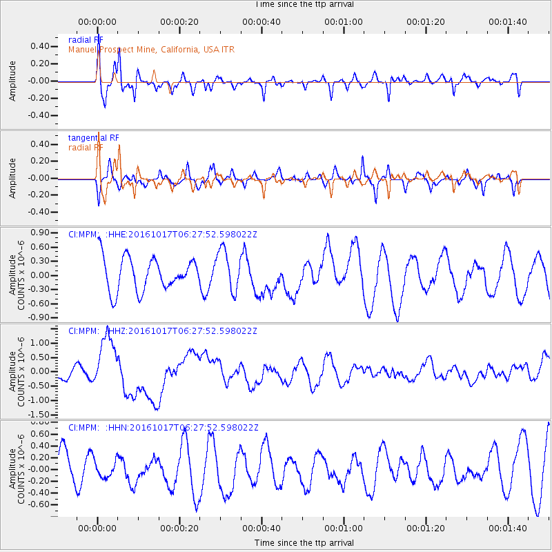
MPM Manuel Prospect Mine, California, USA - Earthquake Result Viewer
*The percent match for this event was below the threshold and hence no stack was calculated.
| Earthquake location: |
New Britain Region, P.N.G. |
| Earthquake latitude/longitude: |
-6.1/148.9 |
| Earthquake time(UTC): |
2016/10/17 (291) 06:14:58 GMT |
| Earthquake Depth: |
35 km |
| Earthquake Magnitude: |
6.9 MO |
| Earthquake Catalog/Contributor: |
NEIC PDE/NEIC ALERT |
|
| Network: |
CI Caltech Regional Seismic Network |
| Station: |
MPM Manuel Prospect Mine, California, USA |
| Lat/Lon: |
36.06 N/117.49 W |
| Elevation: |
185 m |
|
| Distance: |
96.5 deg |
| Az: |
54.472 deg |
| Baz: |
267.244 deg |
| Ray Param: |
$rayparam |
*The percent match for this event was below the threshold and hence was not used in the summary stack. |
|
| Radial Match: |
62.676888 % |
| Radial Bump: |
400 |
| Transverse Match: |
61.64446 % |
| Transverse Bump: |
388 |
| SOD ConfigId: |
11737051 |
| Insert Time: |
2019-04-25 18:44:19.246 +0000 |
| GWidth: |
2.5 |
| Max Bumps: |
400 |
| Tol: |
0.001 |
|
Signal To Noise
| Channel | StoN | STA | LTA |
| CI:MPM: :HHZ:20161017T06:27:52.598022Z | 3.0835059 | 9.669774E-7 | 3.1359676E-7 |
| CI:MPM: :HHN:20161017T06:27:52.598022Z | 0.36023164 | 1.4325691E-7 | 3.9768E-7 |
| CI:MPM: :HHE:20161017T06:27:52.598022Z | 1.2646149 | 4.44487E-7 | 3.5148014E-7 |
| Arrivals |
| Ps | |
| PpPs | |
| PsPs/PpSs | |


