You are here: Home > Network List > IU - Global Seismograph Network (GSN - IRIS/USGS) Stations List
> Station JOHN Johnston Island, USA > Earthquake Result Viewer
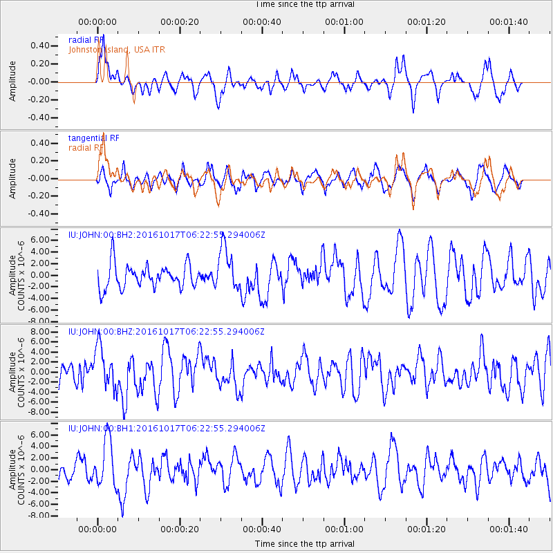
JOHN Johnston Island, USA - Earthquake Result Viewer
*The percent match for this event was below the threshold and hence no stack was calculated.
| Earthquake location: |
New Britain Region, P.N.G. |
| Earthquake latitude/longitude: |
-6.1/148.9 |
| Earthquake time(UTC): |
2016/10/17 (291) 06:14:58 GMT |
| Earthquake Depth: |
35 km |
| Earthquake Magnitude: |
6.9 MO |
| Earthquake Catalog/Contributor: |
NEIC PDE/NEIC ALERT |
|
| Network: |
IU Global Seismograph Network (GSN - IRIS/USGS) |
| Station: |
JOHN Johnston Island, USA |
| Lat/Lon: |
16.73 N/169.53 W |
| Elevation: |
2.0 m |
|
| Distance: |
47.0 deg |
| Az: |
60.526 deg |
| Baz: |
244.631 deg |
| Ray Param: |
$rayparam |
*The percent match for this event was below the threshold and hence was not used in the summary stack. |
|
| Radial Match: |
65.67968 % |
| Radial Bump: |
400 |
| Transverse Match: |
56.263218 % |
| Transverse Bump: |
400 |
| SOD ConfigId: |
11737051 |
| Insert Time: |
2019-04-25 18:46:56.185 +0000 |
| GWidth: |
2.5 |
| Max Bumps: |
400 |
| Tol: |
0.001 |
|
Signal To Noise
| Channel | StoN | STA | LTA |
| IU:JOHN:00:BHZ:20161017T06:22:55.294006Z | 1.8652523 | 4.2449788E-6 | 2.2758202E-6 |
| IU:JOHN:00:BH1:20161017T06:22:55.294006Z | 2.7863128 | 4.2227434E-6 | 1.5155309E-6 |
| IU:JOHN:00:BH2:20161017T06:22:55.294006Z | 1.8671118 | 3.8215144E-6 | 2.0467517E-6 |
| Arrivals |
| Ps | |
| PpPs | |
| PsPs/PpSs | |


