You are here: Home > Network List > KZ - Kazakhstan Network Stations List
> Station MAKZ Makanchi, Kazakstan > Earthquake Result Viewer
MAKZ Makanchi, Kazakstan - Earthquake Result Viewer
| Earthquake location: |
New Britain Region, P.N.G. |
| Earthquake latitude/longitude: |
-6.1/148.9 |
| Earthquake time(UTC): |
2016/10/17 (291) 06:14:58 GMT |
| Earthquake Depth: |
35 km |
| Earthquake Magnitude: |
6.9 MO |
| Earthquake Catalog/Contributor: |
NEIC PDE/NEIC ALERT |
|
| Network: |
KZ Kazakhstan Network |
| Station: |
MAKZ Makanchi, Kazakstan |
| Lat/Lon: |
46.81 N/81.98 E |
| Elevation: |
600 m |
|
| Distance: |
78.9 deg |
| Az: |
319.93 deg |
| Baz: |
111.25 deg |
| Ray Param: |
0.049260546 |
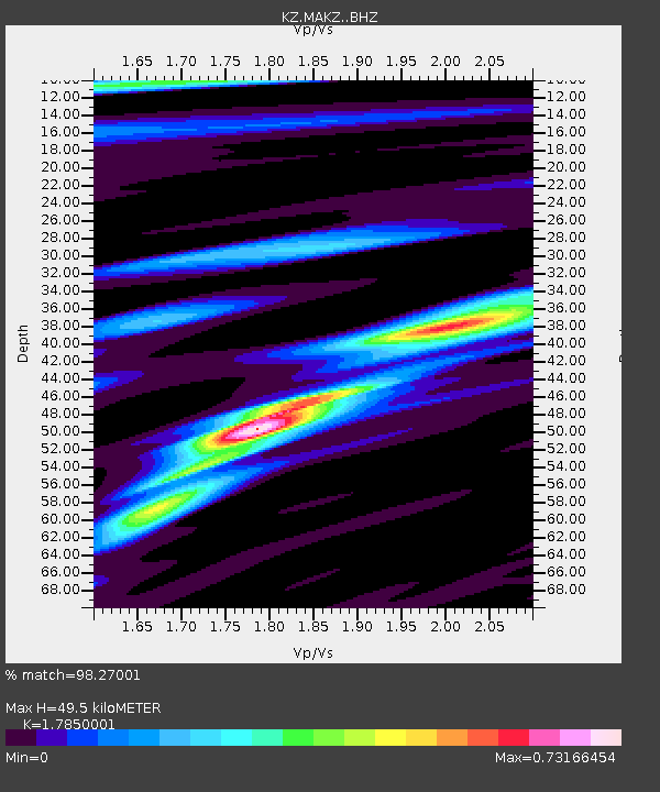
| Estimated Moho Depth: |
49.5 km |
| Estimated Crust Vp/Vs: |
1.79 |
| Assumed Crust Vp: |
6.571 km/s |
| Estimated Crust Vs: |
3.681 km/s |
| Estimated Crust Poisson's Ratio: |
0.27 |
|
| Radial Match: |
98.27001 % |
| Radial Bump: |
326 |
| Transverse Match: |
94.03346 % |
| Transverse Bump: |
400 |
| SOD ConfigId: |
11737051 |
| Insert Time: |
2019-04-25 18:47:46.596 +0000 |
| GWidth: |
2.5 |
| Max Bumps: |
400 |
| Tol: |
0.001 |
|

Signal To Noise
| Channel | StoN | STA | LTA |
| KZ:MAKZ: :BHZ:20161017T06:26:27.244019Z | 78.20675 | 2.8325126E-6 | 3.6218264E-8 |
| KZ:MAKZ: :BHN:20161017T06:26:27.244019Z | 9.15625 | 3.4290414E-7 | 3.745028E-8 |
| KZ:MAKZ: :BHE:20161017T06:26:27.244019Z | 25.77341 | 9.375805E-7 | 3.637782E-8 |
| Arrivals |
| Ps | 6.1 SECOND |
| PpPs | 20 SECOND |
| PsPs/PpSs | 26 SECOND |


