You are here: Home > Network List > PS - Pacific21 Stations List
> Station PSI Parapat, Indonesia > Earthquake Result Viewer
PSI Parapat, Indonesia - Earthquake Result Viewer
| Earthquake location: |
New Britain Region, P.N.G. |
| Earthquake latitude/longitude: |
-6.1/148.9 |
| Earthquake time(UTC): |
2016/10/17 (291) 06:14:58 GMT |
| Earthquake Depth: |
35 km |
| Earthquake Magnitude: |
6.9 MO |
| Earthquake Catalog/Contributor: |
NEIC PDE/NEIC ALERT |
|
| Network: |
PS Pacific21 |
| Station: |
PSI Parapat, Indonesia |
| Lat/Lon: |
2.69 N/98.92 E |
| Elevation: |
987 m |
|
| Distance: |
50.6 deg |
| Az: |
278.464 deg |
| Baz: |
100.022 deg |
| Ray Param: |
0.067864135 |
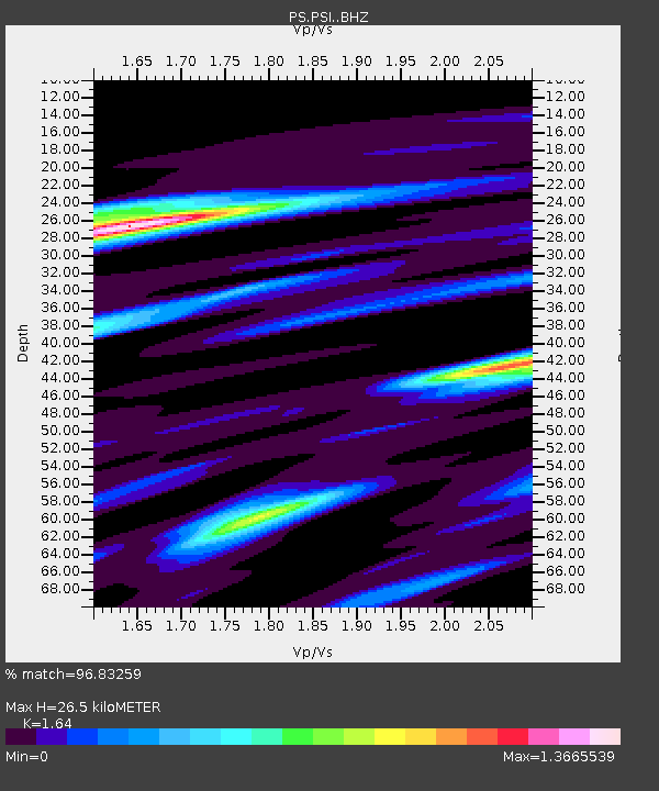
| Estimated Moho Depth: |
26.5 km |
| Estimated Crust Vp/Vs: |
1.64 |
| Assumed Crust Vp: |
6.468 km/s |
| Estimated Crust Vs: |
3.944 km/s |
| Estimated Crust Poisson's Ratio: |
0.20 |
|
| Radial Match: |
96.83259 % |
| Radial Bump: |
384 |
| Transverse Match: |
95.89848 % |
| Transverse Bump: |
400 |
| SOD ConfigId: |
11737051 |
| Insert Time: |
2019-04-25 18:49:14.248 +0000 |
| GWidth: |
2.5 |
| Max Bumps: |
400 |
| Tol: |
0.001 |
|
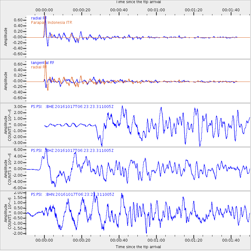
Signal To Noise
| Channel | StoN | STA | LTA |
| PS:PSI: :BHZ:20161017T06:23:23.311005Z | 32.034084 | 3.9252322E-6 | 1.22533E-7 |
| PS:PSI: :BHN:20161017T06:23:23.311005Z | 3.2202446 | 4.0236787E-7 | 1.2494948E-7 |
| PS:PSI: :BHE:20161017T06:23:23.311005Z | 11.9274845 | 1.8895503E-6 | 1.5841984E-7 |
| Arrivals |
| Ps | 2.8 SECOND |
| PpPs | 10 SECOND |
| PsPs/PpSs | 13 SECOND |


