You are here: Home > Network List > S - Seismographs in Schools Projects Stations List
> Station AUALB St Joseph's College, Albany, WA > Earthquake Result Viewer
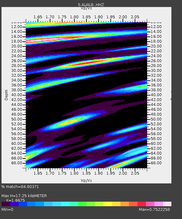
AUALB St Joseph's College, Albany, WA - Earthquake Result Viewer
| Earthquake location: |
New Britain Region, P.N.G. |
| Earthquake latitude/longitude: |
-6.1/148.9 |
| Earthquake time(UTC): |
2016/10/17 (291) 06:14:58 GMT |
| Earthquake Depth: |
35 km |
| Earthquake Magnitude: |
6.9 MO |
| Earthquake Catalog/Contributor: |
NEIC PDE/NEIC ALERT |
|
| Network: |
S Seismographs in Schools Projects |
| Station: |
AUALB St Joseph's College, Albany, WA |
| Lat/Lon: |
35.00 S/117.90 E |
| Elevation: |
50 m |
|
| Distance: |
40.5 deg |
| Az: |
220.52 deg |
| Baz: |
51.911 deg |
| Ray Param: |
0.074272424 |
| Estimated Moho Depth: |
17.25 km |
| Estimated Crust Vp/Vs: |
1.67 |
| Assumed Crust Vp: |
6.467 km/s |
| Estimated Crust Vs: |
3.878 km/s |
| Estimated Crust Poisson's Ratio: |
0.22 |
|
| Radial Match: |
84.80371 % |
| Radial Bump: |
310 |
| Transverse Match: |
63.551735 % |
| Transverse Bump: |
400 |
| SOD ConfigId: |
11737051 |
| Insert Time: |
2019-04-25 18:49:44.541 +0000 |
| GWidth: |
2.5 |
| Max Bumps: |
400 |
| Tol: |
0.001 |
|

Signal To Noise
| Channel | StoN | STA | LTA |
| S:AUALB: :HHZ:20161017T06:22:03.779999Z | 5.065547 | 4.425075E-6 | 8.7356307E-7 |
| S:AUALB: :HHN:20161017T06:22:03.779999Z | 2.1091766 | 1.8268195E-6 | 8.661292E-7 |
| S:AUALB: :HHE:20161017T06:22:03.779999Z | 2.7224681 | 2.0743898E-6 | 7.619519E-7 |
| Arrivals |
| Ps | 1.9 SECOND |
| PpPs | 6.6 SECOND |
| PsPs/PpSs | 8.5 SECOND |


