You are here: Home > Network List > TA - USArray Transportable Network (new EarthScope stations) Stations List
> Station A21K Barrow, AK, USA > Earthquake Result Viewer
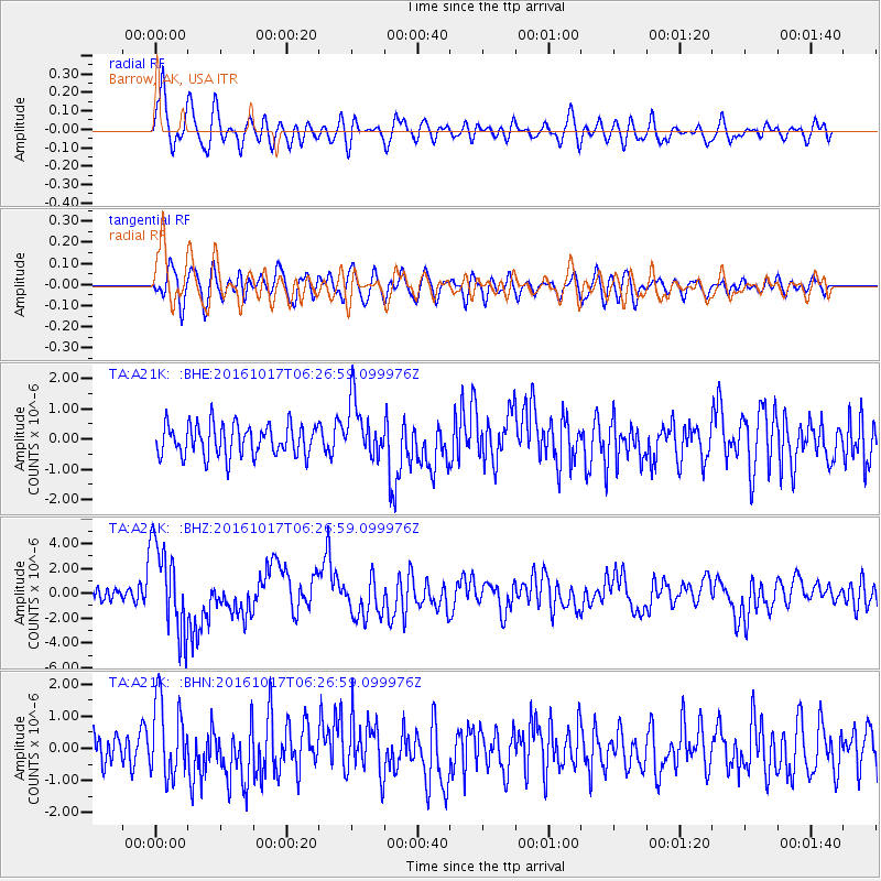
A21K Barrow, AK, USA - Earthquake Result Viewer
*The percent match for this event was below the threshold and hence no stack was calculated.
| Earthquake location: |
New Britain Region, P.N.G. |
| Earthquake latitude/longitude: |
-6.1/148.9 |
| Earthquake time(UTC): |
2016/10/17 (291) 06:14:58 GMT |
| Earthquake Depth: |
35 km |
| Earthquake Magnitude: |
6.9 MO |
| Earthquake Catalog/Contributor: |
NEIC PDE/NEIC ALERT |
|
| Network: |
TA USArray Transportable Network (new EarthScope stations) |
| Station: |
A21K Barrow, AK, USA |
| Lat/Lon: |
71.32 N/156.62 W |
| Elevation: |
577 m |
|
| Distance: |
85.0 deg |
| Az: |
15.269 deg |
| Baz: |
234.382 deg |
| Ray Param: |
$rayparam |
*The percent match for this event was below the threshold and hence was not used in the summary stack. |
|
| Radial Match: |
72.87709 % |
| Radial Bump: |
400 |
| Transverse Match: |
55.0902 % |
| Transverse Bump: |
400 |
| SOD ConfigId: |
11737051 |
| Insert Time: |
2019-04-25 18:50:20.787 +0000 |
| GWidth: |
2.5 |
| Max Bumps: |
400 |
| Tol: |
0.001 |
|
Signal To Noise
| Channel | StoN | STA | LTA |
| TA:A21K: :BHZ:20161017T06:26:59.099976Z | 6.3942657 | 3.6073259E-6 | 5.641502E-7 |
| TA:A21K: :BHN:20161017T06:26:59.099976Z | 2.2068315 | 1.1862896E-6 | 5.375534E-7 |
| TA:A21K: :BHE:20161017T06:26:59.099976Z | 1.8125558 | 9.414187E-7 | 5.1938747E-7 |
| Arrivals |
| Ps | |
| PpPs | |
| PsPs/PpSs | |


