You are here: Home > Network List > TA - USArray Transportable Network (new EarthScope stations) Stations List
> Station I23K Minto, Yukon-Koyukuk, AK, USA > Earthquake Result Viewer
I23K Minto, Yukon-Koyukuk, AK, USA - Earthquake Result Viewer
| Earthquake location: |
New Britain Region, P.N.G. |
| Earthquake latitude/longitude: |
-6.1/148.9 |
| Earthquake time(UTC): |
2016/10/17 (291) 06:14:58 GMT |
| Earthquake Depth: |
35 km |
| Earthquake Magnitude: |
6.9 MO |
| Earthquake Catalog/Contributor: |
NEIC PDE/NEIC ALERT |
|
| Network: |
TA USArray Transportable Network (new EarthScope stations) |
| Station: |
I23K Minto, Yukon-Koyukuk, AK, USA |
| Lat/Lon: |
65.15 N/149.36 W |
| Elevation: |
149 m |
|
| Distance: |
84.0 deg |
| Az: |
21.987 deg |
| Baz: |
241.768 deg |
| Ray Param: |
0.04571364 |
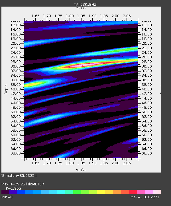
| Estimated Moho Depth: |
29.25 km |
| Estimated Crust Vp/Vs: |
1.86 |
| Assumed Crust Vp: |
6.566 km/s |
| Estimated Crust Vs: |
3.54 km/s |
| Estimated Crust Poisson's Ratio: |
0.30 |
|
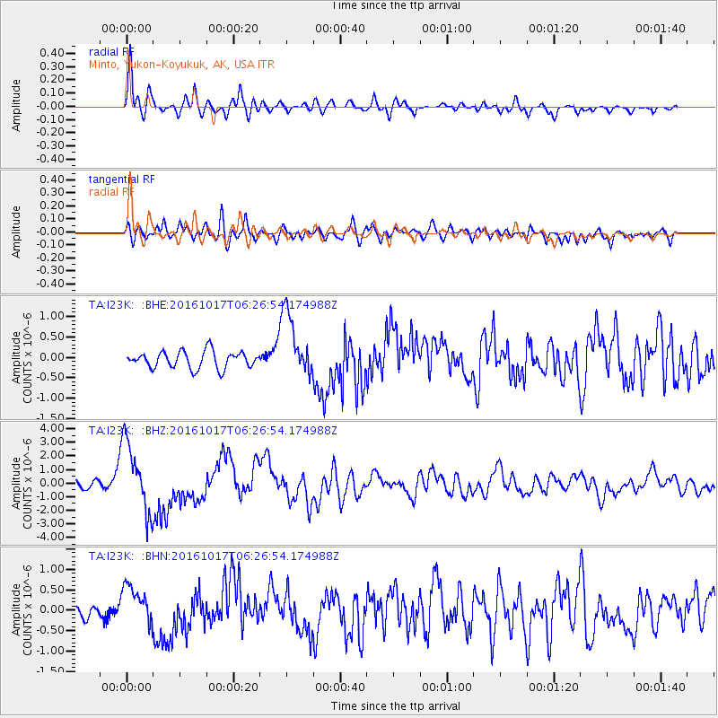
| Radial Match: |
85.63354 % |
| Radial Bump: |
400 |
| Transverse Match: |
70.489204 % |
| Transverse Bump: |
400 |
| SOD ConfigId: |
11737051 |
| Insert Time: |
2019-04-25 18:51:00.340 +0000 |
| GWidth: |
2.5 |
| Max Bumps: |
400 |
| Tol: |
0.001 |
|
Signal To Noise
| Channel | StoN | STA | LTA |
| TA:I23K: :BHZ:20161017T06:26:54.174988Z | 10.780626 | 2.6095106E-6 | 2.4205556E-7 |
| TA:I23K: :BHN:20161017T06:26:54.174988Z | 1.9504211 | 4.871395E-7 | 2.497612E-7 |
| TA:I23K: :BHE:20161017T06:26:54.174988Z | 3.987364 | 8.25343E-7 | 2.0698963E-7 |
| Arrivals |
| Ps | 3.9 SECOND |
| PpPs | 12 SECOND |
| PsPs/PpSs | 16 SECOND |


