You are here: Home > Network List > TA - USArray Transportable Network (new EarthScope stations) Stations List
> Station I29M Ogilvie Camp, Yukon, CA > Earthquake Result Viewer
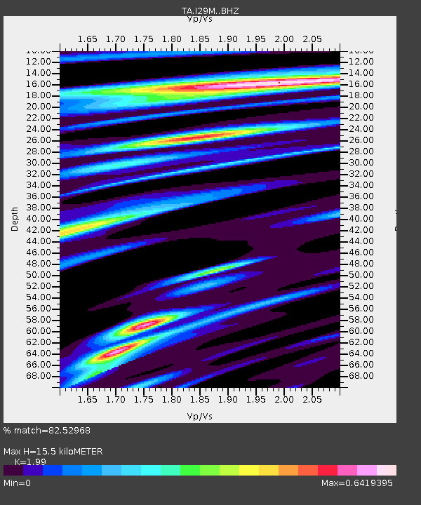
I29M Ogilvie Camp, Yukon, CA - Earthquake Result Viewer
| Earthquake location: |
New Britain Region, P.N.G. |
| Earthquake latitude/longitude: |
-6.1/148.9 |
| Earthquake time(UTC): |
2016/10/17 (291) 06:14:58 GMT |
| Earthquake Depth: |
35 km |
| Earthquake Magnitude: |
6.9 MO |
| Earthquake Catalog/Contributor: |
NEIC PDE/NEIC ALERT |
|
| Network: |
TA USArray Transportable Network (new EarthScope stations) |
| Station: |
I29M Ogilvie Camp, Yukon, CA |
| Lat/Lon: |
65.36 N/138.31 W |
| Elevation: |
602 m |
|
| Distance: |
88.4 deg |
| Az: |
23.622 deg |
| Baz: |
251.908 deg |
| Ray Param: |
0.04257053 |
| Estimated Moho Depth: |
15.5 km |
| Estimated Crust Vp/Vs: |
1.99 |
| Assumed Crust Vp: |
6.566 km/s |
| Estimated Crust Vs: |
3.3 km/s |
| Estimated Crust Poisson's Ratio: |
0.33 |
|
| Radial Match: |
82.52968 % |
| Radial Bump: |
400 |
| Transverse Match: |
68.9744 % |
| Transverse Bump: |
400 |
| SOD ConfigId: |
11737051 |
| Insert Time: |
2019-04-25 18:51:01.911 +0000 |
| GWidth: |
2.5 |
| Max Bumps: |
400 |
| Tol: |
0.001 |
|

Signal To Noise
| Channel | StoN | STA | LTA |
| TA:I29M: :BHZ:20161017T06:27:15.525024Z | 15.631121 | 2.2171782E-6 | 1.4184384E-7 |
| TA:I29M: :BHN:20161017T06:27:15.525024Z | 1.6070334 | 2.6297818E-7 | 1.6364203E-7 |
| TA:I29M: :BHE:20161017T06:27:15.525024Z | 7.30159 | 7.91658E-7 | 1.0842268E-7 |
| Arrivals |
| Ps | 2.4 SECOND |
| PpPs | 6.9 SECOND |
| PsPs/PpSs | 9.3 SECOND |


