You are here: Home > Network List > BK - Berkeley Digital Seismograph Network Stations List
> Station CMB Columbia College, California, USA > Earthquake Result Viewer
CMB Columbia College, California, USA - Earthquake Result Viewer
| Earthquake location: |
Near East Coast Of Kamchatka |
| Earthquake latitude/longitude: |
54.8/162.0 |
| Earthquake time(UTC): |
1997/12/05 (339) 11:26:54 GMT |
| Earthquake Depth: |
33 km |
| Earthquake Magnitude: |
6.3 MB, 7.6 MS, 7.9 UNKNOWN, 7.3 ME |
| Earthquake Catalog/Contributor: |
WHDF/NEIC |
|
| Network: |
BK Berkeley Digital Seismograph Network |
| Station: |
CMB Columbia College, California, USA |
| Lat/Lon: |
38.03 N/120.39 W |
| Elevation: |
719 m |
|
| Distance: |
53.2 deg |
| Az: |
74.327 deg |
| Baz: |
315.147 deg |
| Ray Param: |
0.06618345 |
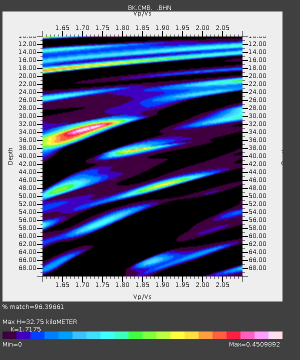
| Estimated Moho Depth: |
32.75 km |
| Estimated Crust Vp/Vs: |
1.72 |
| Assumed Crust Vp: |
6.597 km/s |
| Estimated Crust Vs: |
3.841 km/s |
| Estimated Crust Poisson's Ratio: |
0.24 |
|
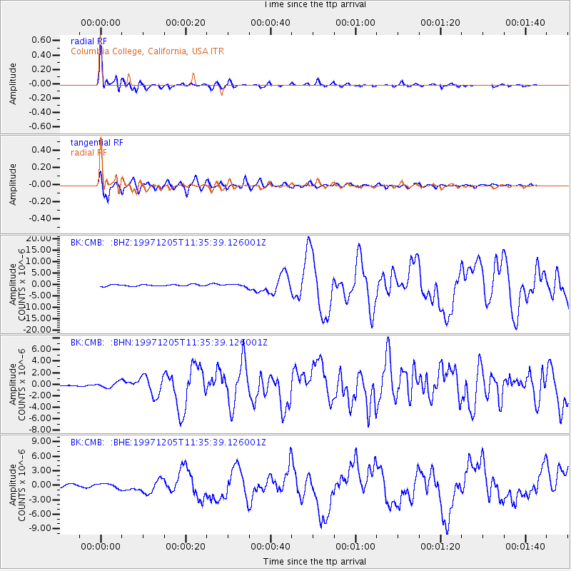
| Radial Match: |
96.39661 % |
| Radial Bump: |
376 |
| Transverse Match: |
91.916626 % |
| Transverse Bump: |
400 |
| SOD ConfigId: |
9875 |
| Insert Time: |
2010-03-05 18:45:10.711 +0000 |
| GWidth: |
2.5 |
| Max Bumps: |
400 |
| Tol: |
0.001 |
|
Signal To Noise
| Channel | StoN | STA | LTA |
| BK:CMB: :BHN:19971205T11:35:39.126001Z | 1.28616 | 5.0529394E-7 | 3.9287022E-7 |
| BK:CMB: :BHE:19971205T11:35:39.126001Z | 1.2215234 | 4.9242266E-7 | 4.0312173E-7 |
| BK:CMB: :BHZ:19971205T11:35:39.126001Z | 1.6284223 | 5.777888E-7 | 3.5481509E-7 |
| Arrivals |
| Ps | 3.8 SECOND |
| PpPs | 13 SECOND |
| PsPs/PpSs | 16 SECOND |


