You are here: Home > Network List > TA - USArray Transportable Network (new EarthScope stations) Stations List
> Station R33M Jennings River, BC, CAN > Earthquake Result Viewer
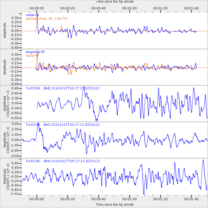
R33M Jennings River, BC, CAN - Earthquake Result Viewer
*The percent match for this event was below the threshold and hence no stack was calculated.
| Earthquake location: |
New Britain Region, P.N.G. |
| Earthquake latitude/longitude: |
-6.1/148.9 |
| Earthquake time(UTC): |
2016/10/17 (291) 06:14:58 GMT |
| Earthquake Depth: |
35 km |
| Earthquake Magnitude: |
6.9 MO |
| Earthquake Catalog/Contributor: |
NEIC PDE/NEIC ALERT |
|
| Network: |
TA USArray Transportable Network (new EarthScope stations) |
| Station: |
R33M Jennings River, BC, CAN |
| Lat/Lon: |
59.39 N/130.97 W |
| Elevation: |
1437 m |
|
| Distance: |
90.2 deg |
| Az: |
30.275 deg |
| Baz: |
258.495 deg |
| Ray Param: |
$rayparam |
*The percent match for this event was below the threshold and hence was not used in the summary stack. |
|
| Radial Match: |
78.212234 % |
| Radial Bump: |
400 |
| Transverse Match: |
61.88163 % |
| Transverse Bump: |
400 |
| SOD ConfigId: |
11737051 |
| Insert Time: |
2019-04-25 18:51:59.819 +0000 |
| GWidth: |
2.5 |
| Max Bumps: |
400 |
| Tol: |
0.001 |
|
Signal To Noise
| Channel | StoN | STA | LTA |
| TA:R33M: :BHZ:20161017T06:27:23.825012Z | 7.8400273 | 1.7963989E-6 | 2.2913171E-7 |
| TA:R33M: :BHN:20161017T06:27:23.825012Z | 0.6686969 | 1.6965531E-7 | 2.5371034E-7 |
| TA:R33M: :BHE:20161017T06:27:23.825012Z | 3.3241556 | 6.2682E-7 | 1.8856517E-7 |
| Arrivals |
| Ps | |
| PpPs | |
| PsPs/PpSs | |


