You are here: Home > Network List > UW - Pacific Northwest Regional Seismic Network Stations List
> Station PASS Maple Falls, WA, USA > Earthquake Result Viewer
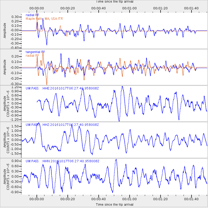
PASS Maple Falls, WA, USA - Earthquake Result Viewer
*The percent match for this event was below the threshold and hence no stack was calculated.
| Earthquake location: |
New Britain Region, P.N.G. |
| Earthquake latitude/longitude: |
-6.1/148.9 |
| Earthquake time(UTC): |
2016/10/17 (291) 06:14:58 GMT |
| Earthquake Depth: |
35 km |
| Earthquake Magnitude: |
6.9 MO |
| Earthquake Catalog/Contributor: |
NEIC PDE/NEIC ALERT |
|
| Network: |
UW Pacific Northwest Regional Seismic Network |
| Station: |
PASS Maple Falls, WA, USA |
| Lat/Lon: |
49.00 N/122.09 W |
| Elevation: |
174 m |
|
| Distance: |
93.9 deg |
| Az: |
41.302 deg |
| Baz: |
265.323 deg |
| Ray Param: |
$rayparam |
*The percent match for this event was below the threshold and hence was not used in the summary stack. |
|
| Radial Match: |
59.561195 % |
| Radial Bump: |
400 |
| Transverse Match: |
54.69726 % |
| Transverse Bump: |
366 |
| SOD ConfigId: |
11737051 |
| Insert Time: |
2019-04-25 18:53:04.544 +0000 |
| GWidth: |
2.5 |
| Max Bumps: |
400 |
| Tol: |
0.001 |
|
Signal To Noise
| Channel | StoN | STA | LTA |
| UW:PASS: :HHZ:20161017T06:27:40.958008Z | 5.123224 | 1.3061914E-6 | 2.5495498E-7 |
| UW:PASS: :HHN:20161017T06:27:40.958008Z | 0.92831206 | 4.2851076E-7 | 4.6160207E-7 |
| UW:PASS: :HHE:20161017T06:27:40.958008Z | 1.7911471 | 6.4671445E-7 | 3.610616E-7 |
| Arrivals |
| Ps | |
| PpPs | |
| PsPs/PpSs | |


