You are here: Home > Network List > YT07 - POLENET Stations List
> Station DEVL DEVL > Earthquake Result Viewer
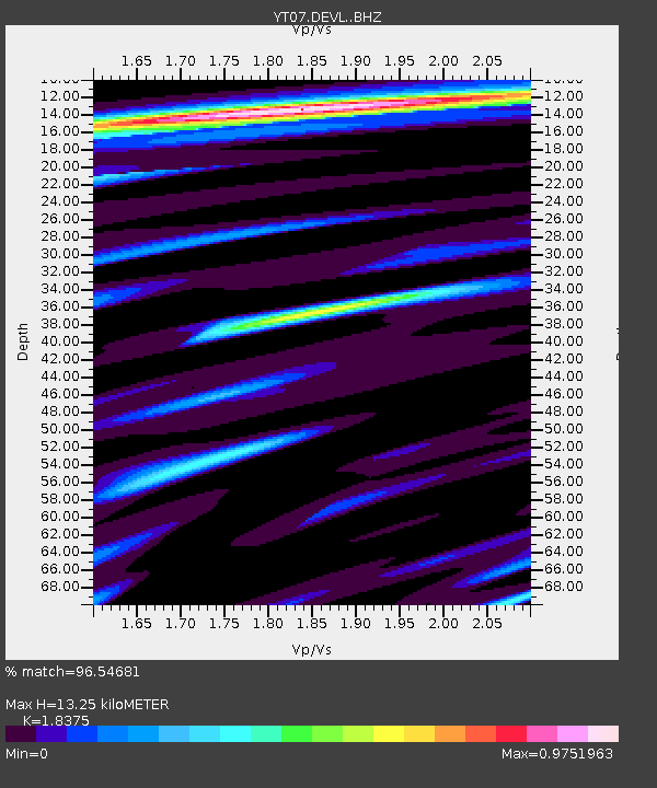
DEVL DEVL - Earthquake Result Viewer
| Earthquake location: |
New Britain Region, P.N.G. |
| Earthquake latitude/longitude: |
-6.1/148.9 |
| Earthquake time(UTC): |
2016/10/17 (291) 06:14:58 GMT |
| Earthquake Depth: |
35 km |
| Earthquake Magnitude: |
6.9 MO |
| Earthquake Catalog/Contributor: |
NEIC PDE/NEIC ALERT |
|
| Network: |
YT POLENET |
| Station: |
DEVL DEVL |
| Lat/Lon: |
81.48 S/161.97 E |
| Elevation: |
101 m |
|
| Distance: |
75.6 deg |
| Az: |
177.998 deg |
| Baz: |
346.534 deg |
| Ray Param: |
0.051483914 |
| Estimated Moho Depth: |
13.25 km |
| Estimated Crust Vp/Vs: |
1.84 |
| Assumed Crust Vp: |
6.43 km/s |
| Estimated Crust Vs: |
3.499 km/s |
| Estimated Crust Poisson's Ratio: |
0.29 |
|
| Radial Match: |
96.54681 % |
| Radial Bump: |
400 |
| Transverse Match: |
91.336975 % |
| Transverse Bump: |
400 |
| SOD ConfigId: |
11737051 |
| Insert Time: |
2019-04-25 18:54:46.194 +0000 |
| GWidth: |
2.5 |
| Max Bumps: |
400 |
| Tol: |
0.001 |
|

Signal To Noise
| Channel | StoN | STA | LTA |
| YT:DEVL: :BHZ:20161017T06:26:08.875Z | 39.77374 | 3.5819708E-6 | 9.0058684E-8 |
| YT:DEVL: :BHN:20161017T06:26:08.875Z | 32.2708 | 1.5414967E-6 | 4.7767536E-8 |
| YT:DEVL: :BHE:20161017T06:26:08.875Z | 15.398882 | 8.4217544E-7 | 5.4690688E-8 |
| Arrivals |
| Ps | 1.8 SECOND |
| PpPs | 5.7 SECOND |
| PsPs/PpSs | 7.4 SECOND |


