You are here: Home > Network List > YT07 - POLENET Stations List
> Station DNTW DNTW > Earthquake Result Viewer
DNTW DNTW - Earthquake Result Viewer
| Earthquake location: |
New Britain Region, P.N.G. |
| Earthquake latitude/longitude: |
-6.1/148.9 |
| Earthquake time(UTC): |
2016/10/17 (291) 06:14:58 GMT |
| Earthquake Depth: |
35 km |
| Earthquake Magnitude: |
6.9 MO |
| Earthquake Catalog/Contributor: |
NEIC PDE/NEIC ALERT |
|
| Network: |
YT POLENET |
| Station: |
DNTW DNTW |
| Lat/Lon: |
76.45 S/107.78 W |
| Elevation: |
1031 m |
|
| Distance: |
87.3 deg |
| Az: |
166.724 deg |
| Baz: |
255.622 deg |
| Ray Param: |
0.043395896 |
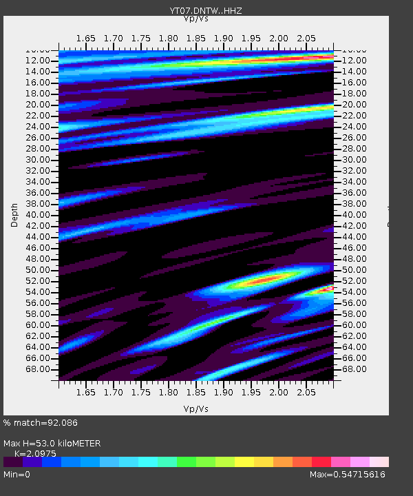
| Estimated Moho Depth: |
53.0 km |
| Estimated Crust Vp/Vs: |
2.10 |
| Assumed Crust Vp: |
5.951 km/s |
| Estimated Crust Vs: |
2.837 km/s |
| Estimated Crust Poisson's Ratio: |
0.35 |
|
| Radial Match: |
92.086 % |
| Radial Bump: |
400 |
| Transverse Match: |
89.43586 % |
| Transverse Bump: |
307 |
| SOD ConfigId: |
11737051 |
| Insert Time: |
2019-04-25 18:54:47.011 +0000 |
| GWidth: |
2.5 |
| Max Bumps: |
400 |
| Tol: |
0.001 |
|

Signal To Noise
| Channel | StoN | STA | LTA |
| YT:DNTW: :HHZ:20161017T06:27:10.140015Z | 49.066334 | 4.8593547E-6 | 9.903644E-8 |
| YT:DNTW: :HHN:20161017T06:27:10.140015Z | 9.168113 | 6.9730095E-7 | 7.60572E-8 |
| YT:DNTW: :HHE:20161017T06:27:10.140015Z | 15.603851 | 1.3380732E-6 | 8.5752745E-8 |
| Arrivals |
| Ps | 9.9 SECOND |
| PpPs | 27 SECOND |
| PsPs/PpSs | 37 SECOND |


