You are here: Home > Network List > BK - Berkeley Digital Seismograph Network Stations List
> Station CMB Columbia College, Columbia, CA > Earthquake Result Viewer
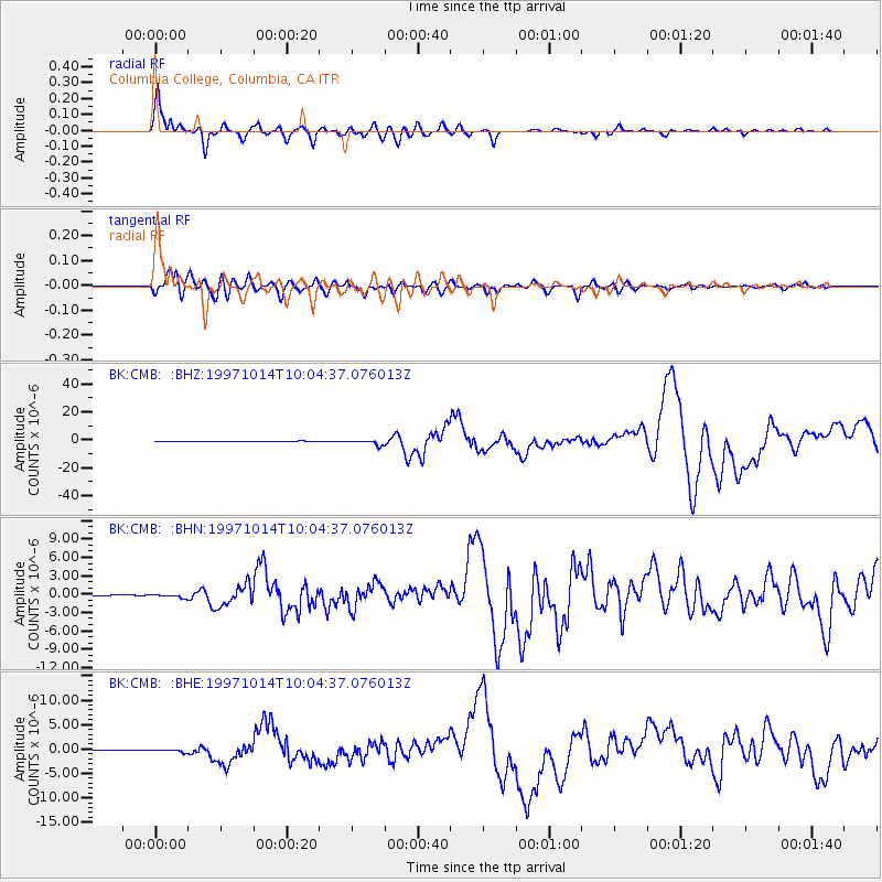
CMB Columbia College, Columbia, CA - Earthquake Result Viewer

| Earthquake location: |
South Of Fiji Islands |
| Earthquake latitude/longitude: |
-22.1/-176.8 |
| Earthquake time(UTC): |
1997/10/14 (287) 09:53:18 GMT |
| Earthquake Depth: |
167 km |
| Earthquake Magnitude: |
6.7 MB, 7.7 UNKNOWN, 7.4 ME |
| Earthquake Catalog/Contributor: |
WHDF/NEIC |
|
| Network: |
BK Berkeley Digital Seismograph Network |
| Station: |
CMB Columbia College, Columbia, CA |
| Lat/Lon: |
38.03 N/120.39 W |
| Elevation: |
697 m |
|
| Distance: |
79.9 deg |
| Az: |
41.914 deg |
| Baz: |
231.679 deg |
| Ray Param: |
0.048260786 |
| Estimated Moho Depth: |
16.5 km |
| Estimated Crust Vp/Vs: |
1.60 |
| Assumed Crust Vp: |
6.597 km/s |
| Estimated Crust Vs: |
4.123 km/s |
| Estimated Crust Poisson's Ratio: |
0.18 |
|
| Radial Match: |
96.38088 % |
| Radial Bump: |
400 |
| Transverse Match: |
90.92634 % |
| Transverse Bump: |
400 |
| SOD ConfigId: |
6273 |
| Insert Time: |
2010-03-05 18:45:48.433 +0000 |
| GWidth: |
2.5 |
| Max Bumps: |
400 |
| Tol: |
0.001 |
|
Signal To Noise
| Channel | StoN | STA | LTA |
| BK:CMB: :BHN:19971014T10:04:37.076013Z | 2.8410738 | 2.7581484E-7 | 9.7081205E-8 |
| BK:CMB: :BHE:19971014T10:04:37.076013Z | 5.183144 | 2.8704923E-7 | 5.5381296E-8 |
| BK:CMB: :BHZ:19971014T10:04:37.076013Z | 15.152143 | 1.9230915E-6 | 1.2691879E-7 |
| Arrivals |
| Ps | 1.6 SECOND |
| PpPs | 6.3 SECOND |
| PsPs/PpSs | 7.8 SECOND |


