You are here: Home > Network List > BK - Berkeley Digital Seismograph Network Stations List
> Station CMB Columbia College, California, USA > Earthquake Result Viewer
CMB Columbia College, California, USA - Earthquake Result Viewer

| Earthquake location: |
Southeast Of Loyalty Islands |
| Earthquake latitude/longitude: |
-22.3/170.9 |
| Earthquake time(UTC): |
1998/01/04 (004) 06:11:58 GMT |
| Earthquake Depth: |
101 km |
| Earthquake Magnitude: |
6.4 MB, 7.4 UNKNOWN, 7.3 ME |
| Earthquake Catalog/Contributor: |
WHDF/NEIC |
|
| Network: |
BK Berkeley Digital Seismograph Network |
| Station: |
CMB Columbia College, California, USA |
| Lat/Lon: |
38.03 N/120.39 W |
| Elevation: |
719 m |
|
| Distance: |
88.0 deg |
| Az: |
47.404 deg |
| Baz: |
239.696 deg |
| Ray Param: |
0.04266644 |
| Estimated Moho Depth: |
16.5 km |
| Estimated Crust Vp/Vs: |
1.61 |
| Assumed Crust Vp: |
6.597 km/s |
| Estimated Crust Vs: |
4.091 km/s |
| Estimated Crust Poisson's Ratio: |
0.19 |
|
| Radial Match: |
97.06505 % |
| Radial Bump: |
382 |
| Transverse Match: |
92.15368 % |
| Transverse Bump: |
400 |
| SOD ConfigId: |
9875 |
| Insert Time: |
2010-03-05 18:46:34.912 +0000 |
| GWidth: |
2.5 |
| Max Bumps: |
400 |
| Tol: |
0.001 |
|
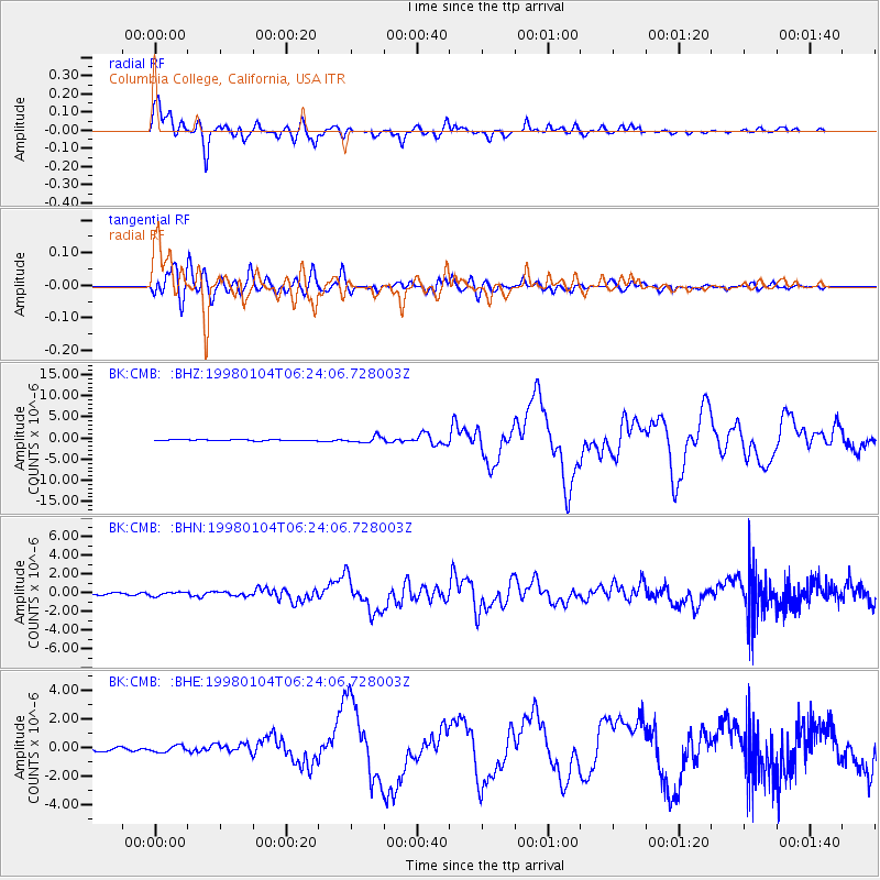
Signal To Noise
| Channel | StoN | STA | LTA |
| BK:CMB: :BHN:19980104T06:24:06.728003Z | 1.7044929 | 1.9865493E-7 | 1.1654782E-7 |
| BK:CMB: :BHE:19980104T06:24:06.728003Z | 1.8899622 | 2.3032851E-7 | 1.2186938E-7 |
| BK:CMB: :BHZ:19980104T06:24:06.728003Z | 5.429027 | 7.569288E-7 | 1.3942255E-7 |
| Arrivals |
| Ps | 1.6 SECOND |
| PpPs | 6.4 SECOND |
| PsPs/PpSs | 7.9 SECOND |


