You are here: Home > Network List > TA - USArray Transportable Network (new EarthScope stations) Stations List
> Station F21K Alatna River, AK, USA > Earthquake Result Viewer
F21K Alatna River, AK, USA - Earthquake Result Viewer
| Earthquake location: |
Xizang |
| Earthquake latitude/longitude: |
32.9/94.9 |
| Earthquake time(UTC): |
2016/10/17 (291) 07:14:50 GMT |
| Earthquake Depth: |
32 km |
| Earthquake Magnitude: |
6.4 MO |
| Earthquake Catalog/Contributor: |
NEIC PDE/NEIC ALERT |
|
| Network: |
TA USArray Transportable Network (new EarthScope stations) |
| Station: |
F21K Alatna River, AK, USA |
| Lat/Lon: |
67.22 N/153.48 W |
| Elevation: |
597 m |
|
| Distance: |
67.8 deg |
| Az: |
23.004 deg |
| Baz: |
302.408 deg |
| Ray Param: |
0.056648556 |
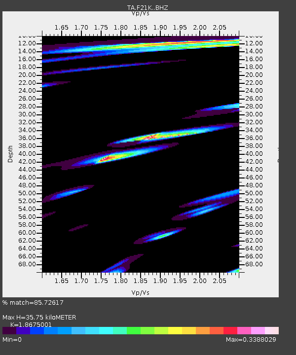
| Estimated Moho Depth: |
35.75 km |
| Estimated Crust Vp/Vs: |
1.87 |
| Assumed Crust Vp: |
6.455 km/s |
| Estimated Crust Vs: |
3.457 km/s |
| Estimated Crust Poisson's Ratio: |
0.30 |
|
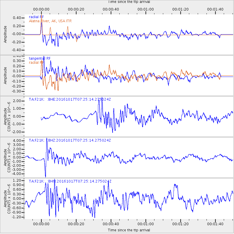
| Radial Match: |
85.72617 % |
| Radial Bump: |
400 |
| Transverse Match: |
71.33205 % |
| Transverse Bump: |
400 |
| SOD ConfigId: |
11737051 |
| Insert Time: |
2019-04-25 19:11:30.760 +0000 |
| GWidth: |
2.5 |
| Max Bumps: |
400 |
| Tol: |
0.001 |
|
Signal To Noise
| Channel | StoN | STA | LTA |
| TA:F21K: :BHZ:20161017T07:25:14.275024Z | 7.434585 | 1.9614047E-6 | 2.6382168E-7 |
| TA:F21K: :BHN:20161017T07:25:14.275024Z | 2.726037 | 6.419909E-7 | 2.3550335E-7 |
| TA:F21K: :BHE:20161017T07:25:14.275024Z | 2.8782282 | 9.541229E-7 | 3.314966E-7 |
| Arrivals |
| Ps | 5.0 SECOND |
| PpPs | 15 SECOND |
| PsPs/PpSs | 20 SECOND |


