You are here: Home > Network List > TA - USArray Transportable Network (new EarthScope stations) Stations List
> Station F26K Sheenjek River, AK, USA > Earthquake Result Viewer
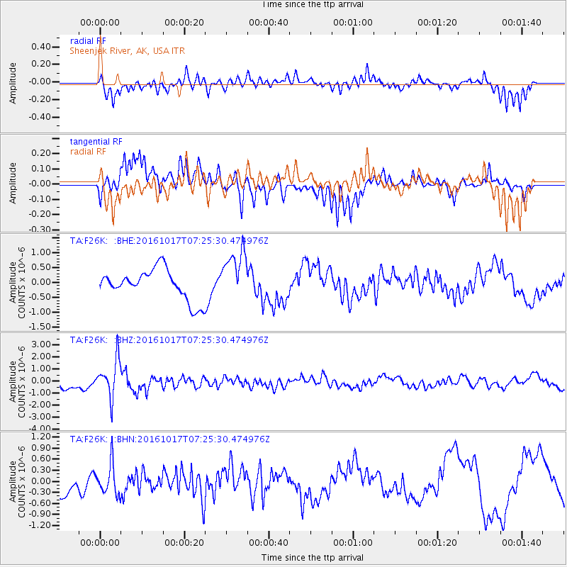
F26K Sheenjek River, AK, USA - Earthquake Result Viewer
*The percent match for this event was below the threshold and hence no stack was calculated.
| Earthquake location: |
Xizang |
| Earthquake latitude/longitude: |
32.9/94.9 |
| Earthquake time(UTC): |
2016/10/17 (291) 07:14:50 GMT |
| Earthquake Depth: |
32 km |
| Earthquake Magnitude: |
6.4 MO |
| Earthquake Catalog/Contributor: |
NEIC PDE/NEIC ALERT |
|
| Network: |
TA USArray Transportable Network (new EarthScope stations) |
| Station: |
F26K Sheenjek River, AK, USA |
| Lat/Lon: |
67.69 N/144.15 W |
| Elevation: |
683 m |
|
| Distance: |
70.5 deg |
| Az: |
20.32 deg |
| Baz: |
310.071 deg |
| Ray Param: |
$rayparam |
*The percent match for this event was below the threshold and hence was not used in the summary stack. |
|
| Radial Match: |
74.730774 % |
| Radial Bump: |
400 |
| Transverse Match: |
66.16348 % |
| Transverse Bump: |
400 |
| SOD ConfigId: |
11737051 |
| Insert Time: |
2019-04-25 19:11:41.557 +0000 |
| GWidth: |
2.5 |
| Max Bumps: |
400 |
| Tol: |
0.001 |
|
Signal To Noise
| Channel | StoN | STA | LTA |
| TA:F26K: :BHZ:20161017T07:25:30.474976Z | 4.689139 | 1.5948385E-6 | 3.401133E-7 |
| TA:F26K: :BHN:20161017T07:25:30.474976Z | 1.4340702 | 4.280171E-7 | 2.9846316E-7 |
| TA:F26K: :BHE:20161017T07:25:30.474976Z | 1.6826187 | 8.508177E-7 | 5.056509E-7 |
| Arrivals |
| Ps | |
| PpPs | |
| PsPs/PpSs | |


