You are here: Home > Network List > TA - USArray Transportable Network (new EarthScope stations) Stations List
> Station J26L Joseph Creek, AK, USA > Earthquake Result Viewer
J26L Joseph Creek, AK, USA - Earthquake Result Viewer
*The percent match for this event was below the threshold and hence no stack was calculated.
| Earthquake location: |
Xizang |
| Earthquake latitude/longitude: |
32.9/94.9 |
| Earthquake time(UTC): |
2016/10/17 (291) 07:14:50 GMT |
| Earthquake Depth: |
32 km |
| Earthquake Magnitude: |
6.4 MO |
| Earthquake Catalog/Contributor: |
NEIC PDE/NEIC ALERT |
|
| Network: |
TA USArray Transportable Network (new EarthScope stations) |
| Station: |
J26L Joseph Creek, AK, USA |
| Lat/Lon: |
64.50 N/143.56 W |
| Elevation: |
1144 m |
|
| Distance: |
72.7 deg |
| Az: |
22.72 deg |
| Baz: |
311.361 deg |
| Ray Param: |
$rayparam |
*The percent match for this event was below the threshold and hence was not used in the summary stack. |
|
| Radial Match: |
74.30989 % |
| Radial Bump: |
400 |
| Transverse Match: |
68.841095 % |
| Transverse Bump: |
400 |
| SOD ConfigId: |
11737051 |
| Insert Time: |
2019-04-25 19:12:16.720 +0000 |
| GWidth: |
2.5 |
| Max Bumps: |
400 |
| Tol: |
0.001 |
|
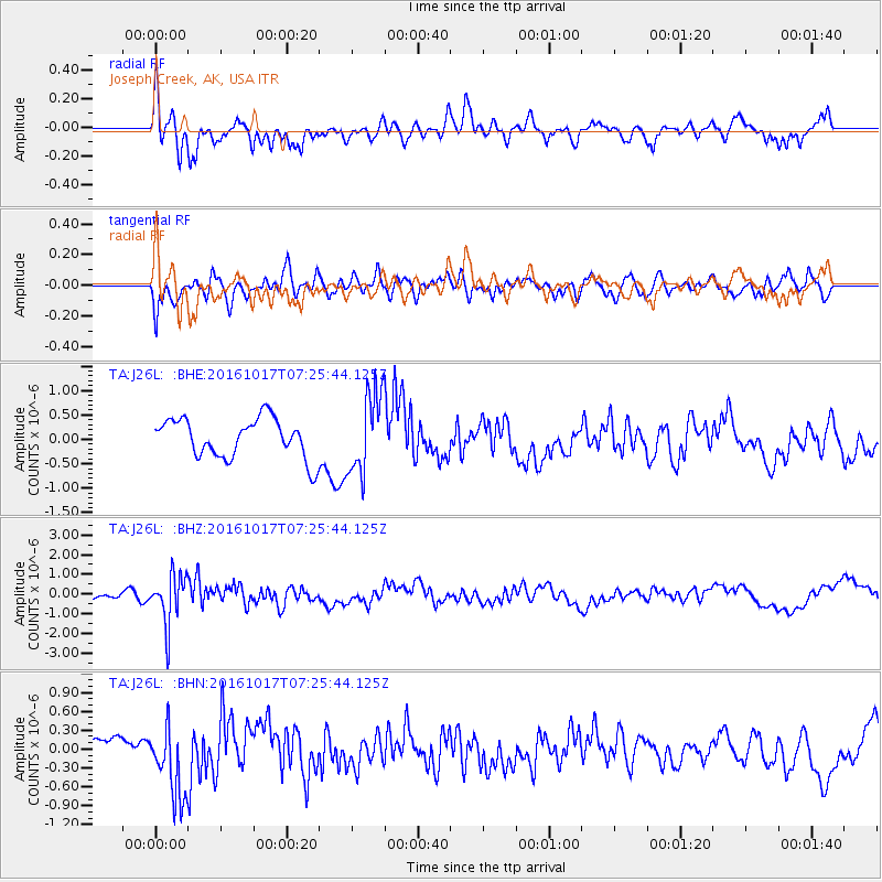
Signal To Noise
| Channel | StoN | STA | LTA |
| TA:J26L: :BHZ:20161017T07:25:44.125Z | 3.4824789 | 1.2561244E-6 | 3.6069835E-7 |
| TA:J26L: :BHN:20161017T07:25:44.125Z | 2.3132265 | 5.835251E-7 | 2.5225594E-7 |
| TA:J26L: :BHE:20161017T07:25:44.125Z | 2.0235431 | 8.0302135E-7 | 3.9683928E-7 |
| Arrivals |
| Ps | |
| PpPs | |
| PsPs/PpSs | |


