You are here: Home > Network List > CI - Caltech Regional Seismic Network Stations List
> Station BEL Belle Mtn, Joshua Tree National Park, CA, USA > Earthquake Result Viewer
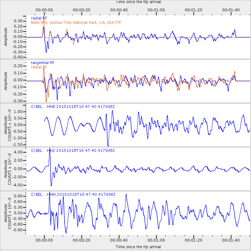
BEL Belle Mtn, Joshua Tree National Park, CA, USA - Earthquake Result Viewer
*The percent match for this event was below the threshold and hence no stack was calculated.
| Earthquake location: |
South Of Fiji Islands |
| Earthquake latitude/longitude: |
-23.3/-179.9 |
| Earthquake time(UTC): |
2016/10/18 (292) 16:36:41 GMT |
| Earthquake Depth: |
540 km |
| Earthquake Magnitude: |
5.9 MWW, 6.0 MWB |
| Earthquake Catalog/Contributor: |
NEIC PDE/NEIC COMCAT |
|
| Network: |
CI Caltech Regional Seismic Network |
| Station: |
BEL Belle Mtn, Joshua Tree National Park, CA, USA |
| Lat/Lon: |
34.00 N/116.00 W |
| Elevation: |
1388 m |
|
| Distance: |
83.3 deg |
| Az: |
48.703 deg |
| Baz: |
236.237 deg |
| Ray Param: |
$rayparam |
*The percent match for this event was below the threshold and hence was not used in the summary stack. |
|
| Radial Match: |
66.15554 % |
| Radial Bump: |
363 |
| Transverse Match: |
63.680878 % |
| Transverse Bump: |
353 |
| SOD ConfigId: |
11737051 |
| Insert Time: |
2019-04-25 19:23:53.154 +0000 |
| GWidth: |
2.5 |
| Max Bumps: |
400 |
| Tol: |
0.001 |
|
Signal To Noise
| Channel | StoN | STA | LTA |
| CI:BEL: :HHZ:20161018T16:47:40.417998Z | 7.1430163 | 2.0248528E-6 | 2.8347307E-7 |
| CI:BEL: :HHN:20161018T16:47:40.417998Z | 1.7396014 | 3.127518E-7 | 1.7978361E-7 |
| CI:BEL: :HHE:20161018T16:47:40.417998Z | 1.6695572 | 6.750642E-7 | 4.0433727E-7 |
| Arrivals |
| Ps | |
| PpPs | |
| PsPs/PpSs | |


