You are here: Home > Network List > CI - Caltech Regional Seismic Network Stations List
> Station SHO Shoshone, CA, USA > Earthquake Result Viewer
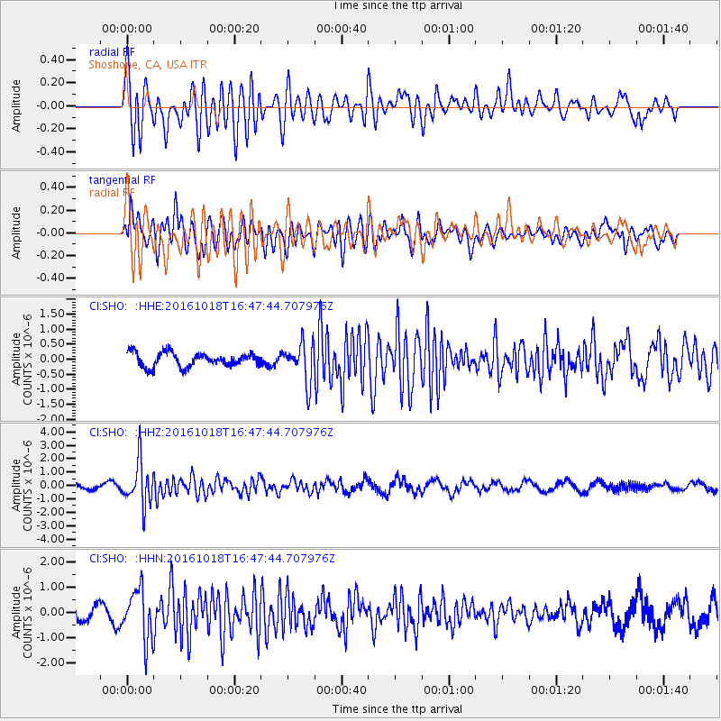
SHO Shoshone, CA, USA - Earthquake Result Viewer
*The percent match for this event was below the threshold and hence no stack was calculated.
| Earthquake location: |
South Of Fiji Islands |
| Earthquake latitude/longitude: |
-23.3/-179.9 |
| Earthquake time(UTC): |
2016/10/18 (292) 16:36:41 GMT |
| Earthquake Depth: |
540 km |
| Earthquake Magnitude: |
5.9 MWW, 6.0 MWB |
| Earthquake Catalog/Contributor: |
NEIC PDE/NEIC COMCAT |
|
| Network: |
CI Caltech Regional Seismic Network |
| Station: |
SHO Shoshone, CA, USA |
| Lat/Lon: |
35.90 N/116.28 W |
| Elevation: |
451 m |
|
| Distance: |
84.2 deg |
| Az: |
46.994 deg |
| Baz: |
235.893 deg |
| Ray Param: |
$rayparam |
*The percent match for this event was below the threshold and hence was not used in the summary stack. |
|
| Radial Match: |
82.09778 % |
| Radial Bump: |
400 |
| Transverse Match: |
72.97063 % |
| Transverse Bump: |
400 |
| SOD ConfigId: |
11737051 |
| Insert Time: |
2019-04-25 19:24:54.516 +0000 |
| GWidth: |
2.5 |
| Max Bumps: |
400 |
| Tol: |
0.001 |
|
Signal To Noise
| Channel | StoN | STA | LTA |
| CI:SHO: :HHZ:20161018T16:47:44.707976Z | 12.196907 | 1.6329797E-6 | 1.3388473E-7 |
| CI:SHO: :HHN:20161018T16:47:44.707976Z | 4.709844 | 1.0074713E-6 | 2.1390755E-7 |
| CI:SHO: :HHE:20161018T16:47:44.707976Z | 2.8880956 | 6.5896927E-7 | 2.281674E-7 |
| Arrivals |
| Ps | |
| PpPs | |
| PsPs/PpSs | |


