You are here: Home > Network List > TA - USArray Transportable Network (new EarthScope stations) Stations List
> Station J20K Nowitna River, AK, USA > Earthquake Result Viewer
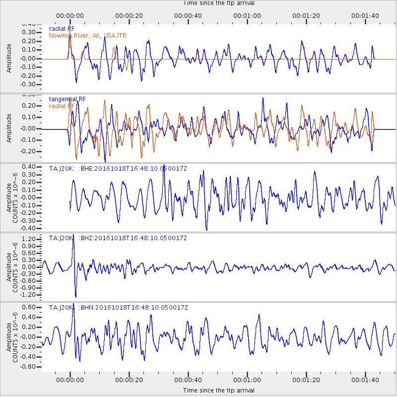
J20K Nowitna River, AK, USA - Earthquake Result Viewer
*The percent match for this event was below the threshold and hence no stack was calculated.
| Earthquake location: |
South Of Fiji Islands |
| Earthquake latitude/longitude: |
-23.3/-179.9 |
| Earthquake time(UTC): |
2016/10/18 (292) 16:36:41 GMT |
| Earthquake Depth: |
540 km |
| Earthquake Magnitude: |
5.9 MWW, 6.0 MWB |
| Earthquake Catalog/Contributor: |
NEIC PDE/NEIC COMCAT |
|
| Network: |
TA USArray Transportable Network (new EarthScope stations) |
| Station: |
J20K Nowitna River, AK, USA |
| Lat/Lon: |
64.18 N/154.15 W |
| Elevation: |
314 m |
|
| Distance: |
89.5 deg |
| Az: |
10.978 deg |
| Baz: |
203.559 deg |
| Ray Param: |
$rayparam |
*The percent match for this event was below the threshold and hence was not used in the summary stack. |
|
| Radial Match: |
59.84141 % |
| Radial Bump: |
396 |
| Transverse Match: |
66.39924 % |
| Transverse Bump: |
400 |
| SOD ConfigId: |
11737051 |
| Insert Time: |
2019-04-25 19:31:59.897 +0000 |
| GWidth: |
2.5 |
| Max Bumps: |
400 |
| Tol: |
0.001 |
|
Signal To Noise
| Channel | StoN | STA | LTA |
| TA:J20K: :BHZ:20161018T16:48:10.050017Z | 3.8372676 | 5.3850374E-7 | 1.403352E-7 |
| TA:J20K: :BHN:20161018T16:48:10.050017Z | 2.473636 | 2.7911608E-7 | 1.1283636E-7 |
| TA:J20K: :BHE:20161018T16:48:10.050017Z | 1.5402493 | 1.8506928E-7 | 1.201554E-7 |
| Arrivals |
| Ps | |
| PpPs | |
| PsPs/PpSs | |


