You are here: Home > Network List > BK - Berkeley Digital Seismograph Network Stations List
> Station CMB Columbia College, California, USA > Earthquake Result Viewer
CMB Columbia College, California, USA - Earthquake Result Viewer
| Earthquake location: |
Tonga Islands |
| Earthquake latitude/longitude: |
-20.2/-174.1 |
| Earthquake time(UTC): |
2006/05/03 (123) 15:26:40 GMT |
| Earthquake Depth: |
55 km |
| Earthquake Magnitude: |
7.2 MB, 7.8 MS, 7.9 MW, 7.9 MW |
| Earthquake Catalog/Contributor: |
WHDF/NEIC |
|
| Network: |
BK Berkeley Digital Seismograph Network |
| Station: |
CMB Columbia College, California, USA |
| Lat/Lon: |
38.03 N/120.39 W |
| Elevation: |
719 m |
|
| Distance: |
76.8 deg |
| Az: |
40.841 deg |
| Baz: |
231.071 deg |
| Ray Param: |
0.050640903 |
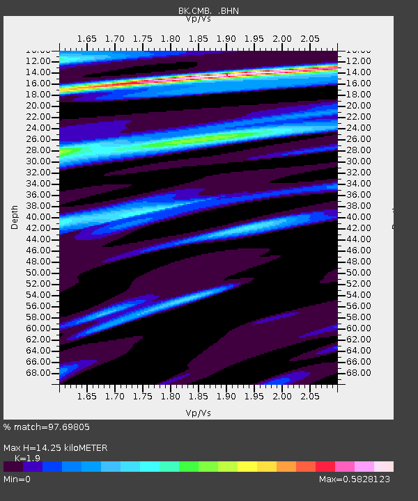
| Estimated Moho Depth: |
14.25 km |
| Estimated Crust Vp/Vs: |
1.90 |
| Assumed Crust Vp: |
6.597 km/s |
| Estimated Crust Vs: |
3.472 km/s |
| Estimated Crust Poisson's Ratio: |
0.31 |
|
| Radial Match: |
97.69805 % |
| Radial Bump: |
285 |
| Transverse Match: |
90.01315 % |
| Transverse Bump: |
400 |
| SOD ConfigId: |
2669 |
| Insert Time: |
2010-03-05 18:50:35.829 +0000 |
| GWidth: |
2.5 |
| Max Bumps: |
400 |
| Tol: |
0.001 |
|

Signal To Noise
| Channel | StoN | STA | LTA |
| BK:CMB: :BHN:20060503T15:37:55.172019Z | 2.4546125 | 3.3204256E-7 | 1.352729E-7 |
| BK:CMB: :BHE:20060503T15:37:55.172019Z | 2.0042634 | 3.7835574E-7 | 1.8877547E-7 |
| BK:CMB: :BHZ:20060503T15:37:55.172019Z | 6.0011544 | 1.8684085E-6 | 3.1134152E-7 |
| Arrivals |
| Ps | 2.0 SECOND |
| PpPs | 6.1 SECOND |
| PsPs/PpSs | 8.1 SECOND |


