You are here: Home > Network List > TA - USArray Transportable Network (new EarthScope stations) Stations List
> Station M24K Tolsona, Glennallen, AK, USA > Earthquake Result Viewer
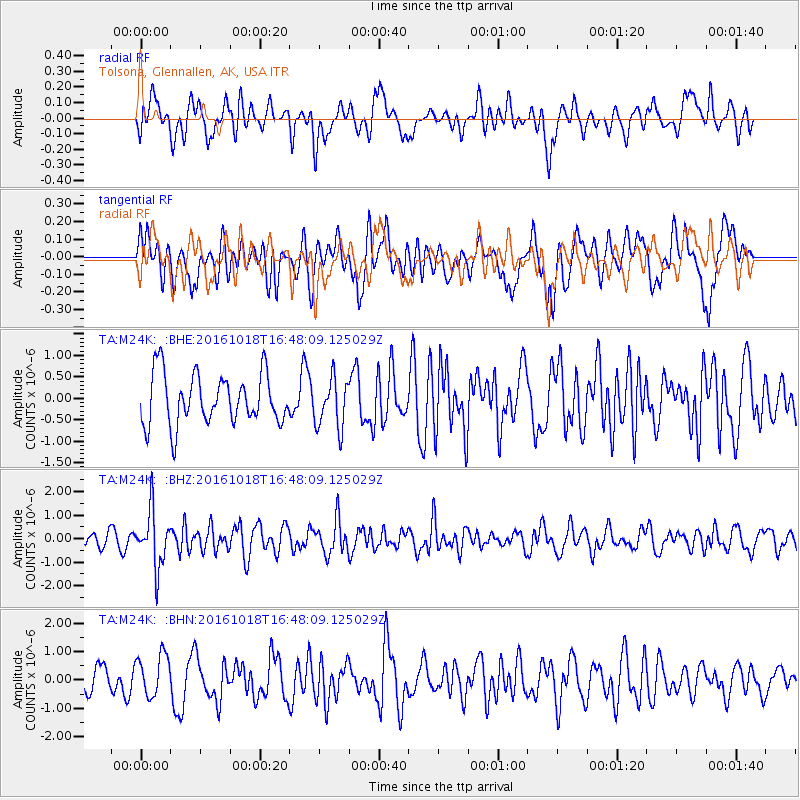
M24K Tolsona, Glennallen, AK, USA - Earthquake Result Viewer
*The percent match for this event was below the threshold and hence no stack was calculated.
| Earthquake location: |
South Of Fiji Islands |
| Earthquake latitude/longitude: |
-23.3/-179.9 |
| Earthquake time(UTC): |
2016/10/18 (292) 16:36:41 GMT |
| Earthquake Depth: |
540 km |
| Earthquake Magnitude: |
5.9 MWW, 6.0 MWB |
| Earthquake Catalog/Contributor: |
NEIC PDE/NEIC COMCAT |
|
| Network: |
TA USArray Transportable Network (new EarthScope stations) |
| Station: |
M24K Tolsona, Glennallen, AK, USA |
| Lat/Lon: |
62.11 N/146.18 W |
| Elevation: |
908 m |
|
| Distance: |
89.3 deg |
| Az: |
15.144 deg |
| Baz: |
210.708 deg |
| Ray Param: |
$rayparam |
*The percent match for this event was below the threshold and hence was not used in the summary stack. |
|
| Radial Match: |
51.03131 % |
| Radial Bump: |
400 |
| Transverse Match: |
47.537655 % |
| Transverse Bump: |
400 |
| SOD ConfigId: |
11737051 |
| Insert Time: |
2019-04-25 19:32:25.158 +0000 |
| GWidth: |
2.5 |
| Max Bumps: |
400 |
| Tol: |
0.001 |
|
Signal To Noise
| Channel | StoN | STA | LTA |
| TA:M24K: :BHZ:20161018T16:48:09.125029Z | 3.44353 | 1.1783528E-6 | 3.4219326E-7 |
| TA:M24K: :BHN:20161018T16:48:09.125029Z | 1.9786426 | 7.3519914E-7 | 3.7156744E-7 |
| TA:M24K: :BHE:20161018T16:48:09.125029Z | 0.98794836 | 5.794232E-7 | 5.864914E-7 |
| Arrivals |
| Ps | |
| PpPs | |
| PsPs/PpSs | |


