You are here: Home > Network List > TA - USArray Transportable Network (new EarthScope stations) Stations List
> Station N23A Red Feather Lakes, CO, USA > Earthquake Result Viewer
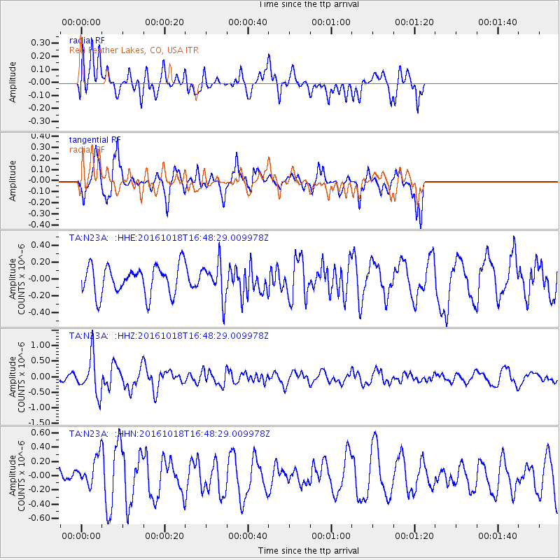
N23A Red Feather Lakes, CO, USA - Earthquake Result Viewer
*The percent match for this event was below the threshold and hence no stack was calculated.
| Earthquake location: |
South Of Fiji Islands |
| Earthquake latitude/longitude: |
-23.3/-179.9 |
| Earthquake time(UTC): |
2016/10/18 (292) 16:36:41 GMT |
| Earthquake Depth: |
540 km |
| Earthquake Magnitude: |
5.9 MWW, 6.0 MWB |
| Earthquake Catalog/Contributor: |
NEIC PDE/NEIC COMCAT |
|
| Network: |
TA USArray Transportable Network (new EarthScope stations) |
| Station: |
N23A Red Feather Lakes, CO, USA |
| Lat/Lon: |
40.89 N/105.94 W |
| Elevation: |
2458 m |
|
| Distance: |
93.7 deg |
| Az: |
46.897 deg |
| Baz: |
242.298 deg |
| Ray Param: |
$rayparam |
*The percent match for this event was below the threshold and hence was not used in the summary stack. |
|
| Radial Match: |
66.544014 % |
| Radial Bump: |
400 |
| Transverse Match: |
61.67165 % |
| Transverse Bump: |
338 |
| SOD ConfigId: |
11737051 |
| Insert Time: |
2019-04-25 19:32:35.298 +0000 |
| GWidth: |
2.5 |
| Max Bumps: |
400 |
| Tol: |
0.001 |
|
Signal To Noise
| Channel | StoN | STA | LTA |
| TA:N23A: :HHZ:20161018T16:48:29.009978Z | 3.945529 | 6.205683E-7 | 1.5728392E-7 |
| TA:N23A: :HHN:20161018T16:48:29.009978Z | 1.8483645 | 2.3332207E-7 | 1.2623164E-7 |
| TA:N23A: :HHE:20161018T16:48:29.009978Z | 1.2547609 | 2.1690393E-7 | 1.7286476E-7 |
| Arrivals |
| Ps | |
| PpPs | |
| PsPs/PpSs | |


