You are here: Home > Network List > TA - USArray Transportable Network (new EarthScope stations) Stations List
> Station TPFO Pinon Flats, CA, USA > Earthquake Result Viewer
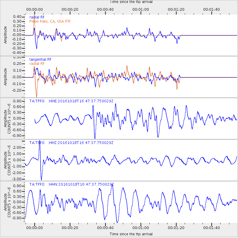
TPFO Pinon Flats, CA, USA - Earthquake Result Viewer
*The percent match for this event was below the threshold and hence no stack was calculated.
| Earthquake location: |
South Of Fiji Islands |
| Earthquake latitude/longitude: |
-23.3/-179.9 |
| Earthquake time(UTC): |
2016/10/18 (292) 16:36:41 GMT |
| Earthquake Depth: |
540 km |
| Earthquake Magnitude: |
5.9 MWW, 6.0 MWB |
| Earthquake Catalog/Contributor: |
NEIC PDE/NEIC COMCAT |
|
| Network: |
TA USArray Transportable Network (new EarthScope stations) |
| Station: |
TPFO Pinon Flats, CA, USA |
| Lat/Lon: |
33.61 N/116.45 W |
| Elevation: |
1275 m |
|
| Distance: |
82.8 deg |
| Az: |
48.819 deg |
| Baz: |
235.999 deg |
| Ray Param: |
$rayparam |
*The percent match for this event was below the threshold and hence was not used in the summary stack. |
|
| Radial Match: |
74.56098 % |
| Radial Bump: |
393 |
| Transverse Match: |
66.0604 % |
| Transverse Bump: |
339 |
| SOD ConfigId: |
11737051 |
| Insert Time: |
2019-04-25 19:33:13.012 +0000 |
| GWidth: |
2.5 |
| Max Bumps: |
400 |
| Tol: |
0.001 |
|
Signal To Noise
| Channel | StoN | STA | LTA |
| TA:TPFO: :HHZ:20161018T16:47:37.750029Z | 1.8936634 | 1.4443584E-6 | 7.627324E-7 |
| TA:TPFO: :HHN:20161018T16:47:37.750029Z | 0.76937544 | 4.150097E-7 | 5.394112E-7 |
| TA:TPFO: :HHE:20161018T16:47:37.750029Z | 2.7685664 | 4.2891963E-7 | 1.549248E-7 |
| Arrivals |
| Ps | |
| PpPs | |
| PsPs/PpSs | |


