You are here: Home > Network List > UW - Pacific Northwest Regional Seismic Network Stations List
> Station PASS Maple Falls, WA, USA > Earthquake Result Viewer
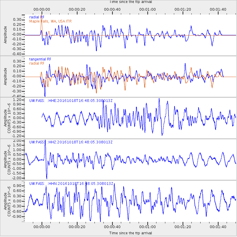
PASS Maple Falls, WA, USA - Earthquake Result Viewer
*The percent match for this event was below the threshold and hence no stack was calculated.
| Earthquake location: |
South Of Fiji Islands |
| Earthquake latitude/longitude: |
-23.3/-179.9 |
| Earthquake time(UTC): |
2016/10/18 (292) 16:36:41 GMT |
| Earthquake Depth: |
540 km |
| Earthquake Magnitude: |
5.9 MWW, 6.0 MWB |
| Earthquake Catalog/Contributor: |
NEIC PDE/NEIC COMCAT |
|
| Network: |
UW Pacific Northwest Regional Seismic Network |
| Station: |
PASS Maple Falls, WA, USA |
| Lat/Lon: |
49.00 N/122.09 W |
| Elevation: |
174 m |
|
| Distance: |
88.5 deg |
| Az: |
33.896 deg |
| Baz: |
231.117 deg |
| Ray Param: |
$rayparam |
*The percent match for this event was below the threshold and hence was not used in the summary stack. |
|
| Radial Match: |
59.971756 % |
| Radial Bump: |
400 |
| Transverse Match: |
56.342613 % |
| Transverse Bump: |
400 |
| SOD ConfigId: |
11737051 |
| Insert Time: |
2019-04-25 19:34:30.573 +0000 |
| GWidth: |
2.5 |
| Max Bumps: |
400 |
| Tol: |
0.001 |
|
Signal To Noise
| Channel | StoN | STA | LTA |
| UW:PASS: :HHZ:20161018T16:48:05.308013Z | 1.8737828 | 8.74124E-7 | 4.665023E-7 |
| UW:PASS: :HHN:20161018T16:48:05.308013Z | 1.216127 | 4.0613557E-7 | 3.3395818E-7 |
| UW:PASS: :HHE:20161018T16:48:05.308013Z | 1.6026355 | 4.0623374E-7 | 2.5347856E-7 |
| Arrivals |
| Ps | |
| PpPs | |
| PsPs/PpSs | |


