You are here: Home > Network List > AK - Alaska Regional Network Stations List
> Station GAMB Gambell Broadband > Earthquake Result Viewer
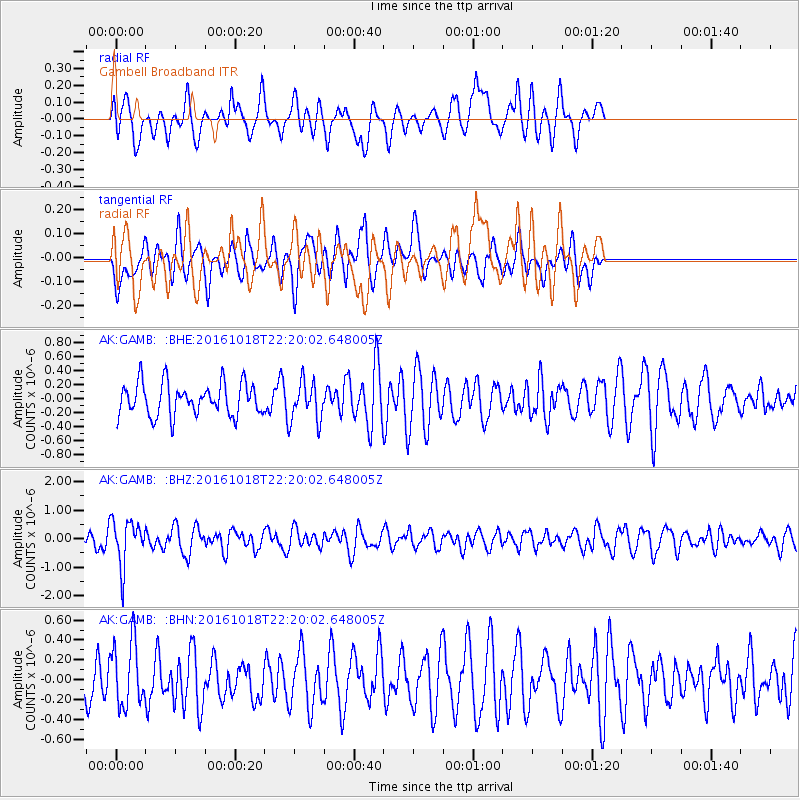
GAMB Gambell Broadband - Earthquake Result Viewer
*The percent match for this event was below the threshold and hence no stack was calculated.
| Earthquake location: |
Leeward Islands |
| Earthquake latitude/longitude: |
15.2/-61.5 |
| Earthquake time(UTC): |
2016/10/18 (292) 22:08:14 GMT |
| Earthquake Depth: |
143 km |
| Earthquake Magnitude: |
5.6 MWW, 5.6 MWB |
| Earthquake Catalog/Contributor: |
NEIC PDE/NEIC COMCAT |
|
| Network: |
AK Alaska Regional Network |
| Station: |
GAMB Gambell Broadband |
| Lat/Lon: |
63.78 N/171.70 W |
| Elevation: |
10 m |
|
| Distance: |
85.1 deg |
| Az: |
335.259 deg |
| Baz: |
65.425 deg |
| Ray Param: |
$rayparam |
*The percent match for this event was below the threshold and hence was not used in the summary stack. |
|
| Radial Match: |
61.884853 % |
| Radial Bump: |
400 |
| Transverse Match: |
43.146065 % |
| Transverse Bump: |
400 |
| SOD ConfigId: |
11737051 |
| Insert Time: |
2019-04-25 19:41:17.290 +0000 |
| GWidth: |
2.5 |
| Max Bumps: |
400 |
| Tol: |
0.001 |
|
Signal To Noise
| Channel | StoN | STA | LTA |
| AK:GAMB: :BHZ:20161018T22:20:02.648005Z | 2.4928203 | 8.00198E-7 | 3.2100107E-7 |
| AK:GAMB: :BHN:20161018T22:20:02.648005Z | 1.1900725 | 3.2340904E-7 | 2.7175574E-7 |
| AK:GAMB: :BHE:20161018T22:20:02.648005Z | 1.1488149 | 2.6276123E-7 | 2.2872374E-7 |
| Arrivals |
| Ps | |
| PpPs | |
| PsPs/PpSs | |


