You are here: Home > Network List > IU - Global Seismograph Network (GSN - IRIS/USGS) Stations List
> Station RSSD Black Hills, South Dakota, USA > Earthquake Result Viewer
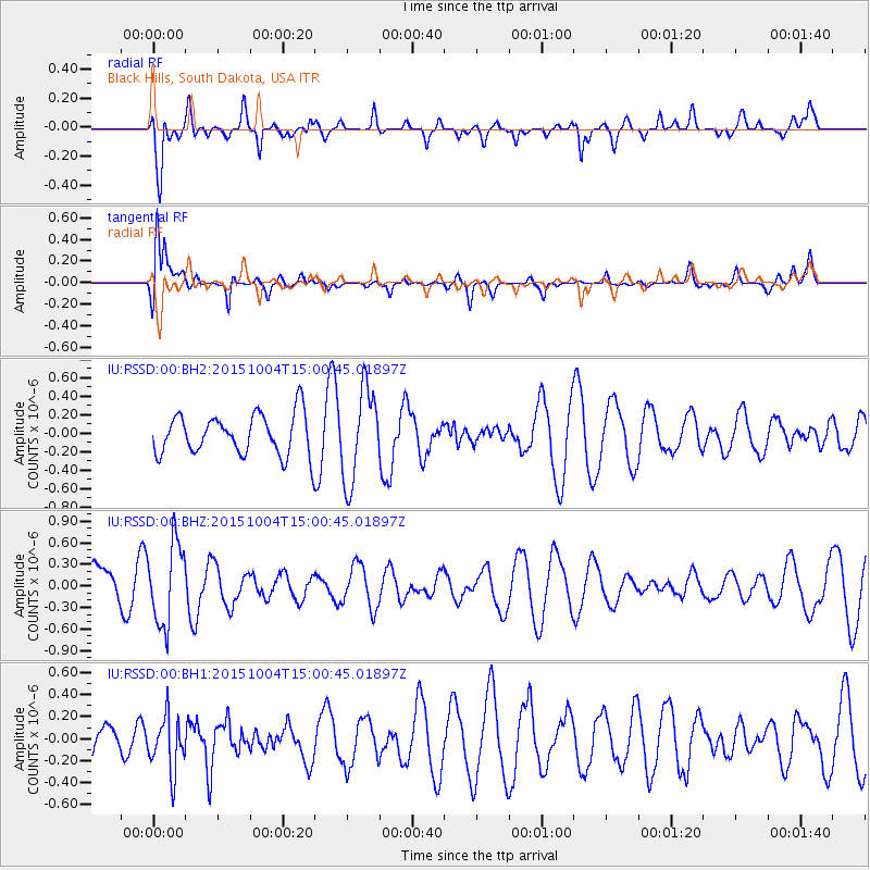
RSSD Black Hills, South Dakota, USA - Earthquake Result Viewer
*The percent match for this event was below the threshold and hence no stack was calculated.
| Earthquake location: |
Near Coast Of Peru |
| Earthquake latitude/longitude: |
-16.3/-72.2 |
| Earthquake time(UTC): |
2015/10/04 (277) 14:50:32 GMT |
| Earthquake Depth: |
72 km |
| Earthquake Magnitude: |
5.6 MB |
| Earthquake Catalog/Contributor: |
NEIC PDE/NEIC COMCAT |
|
| Network: |
IU Global Seismograph Network (GSN - IRIS/USGS) |
| Station: |
RSSD Black Hills, South Dakota, USA |
| Lat/Lon: |
44.12 N/104.04 W |
| Elevation: |
2090 m |
|
| Distance: |
66.7 deg |
| Az: |
335.593 deg |
| Baz: |
146.557 deg |
| Ray Param: |
$rayparam |
*The percent match for this event was below the threshold and hence was not used in the summary stack. |
|
| Radial Match: |
72.945435 % |
| Radial Bump: |
400 |
| Transverse Match: |
65.16022 % |
| Transverse Bump: |
400 |
| SOD ConfigId: |
1156111 |
| Insert Time: |
2015-10-18 15:11:22.153 +0000 |
| GWidth: |
2.5 |
| Max Bumps: |
400 |
| Tol: |
0.001 |
|
Signal To Noise
| Channel | StoN | STA | LTA |
| IU:RSSD:00:BHZ:20151004T15:00:45.01897Z | 1.3663001 | 5.6510396E-7 | 4.1360164E-7 |
| IU:RSSD:00:BH1:20151004T15:00:45.01897Z | 0.8666889 | 2.4640914E-7 | 2.8431094E-7 |
| IU:RSSD:00:BH2:20151004T15:00:45.01897Z | 2.298826 | 5.026098E-7 | 2.1863761E-7 |
| Arrivals |
| Ps | |
| PpPs | |
| PsPs/PpSs | |


