You are here: Home > Network List > TA - USArray Transportable Network (new EarthScope stations) Stations List
> Station G23K Bananza Creek, AK, USA > Earthquake Result Viewer
G23K Bananza Creek, AK, USA - Earthquake Result Viewer
*The percent match for this event was below the threshold and hence no stack was calculated.
| Earthquake location: |
Leeward Islands |
| Earthquake latitude/longitude: |
15.2/-61.5 |
| Earthquake time(UTC): |
2016/10/18 (292) 22:08:14 GMT |
| Earthquake Depth: |
143 km |
| Earthquake Magnitude: |
5.6 MWW, 5.6 MWB |
| Earthquake Catalog/Contributor: |
NEIC PDE/NEIC COMCAT |
|
| Network: |
TA USArray Transportable Network (new EarthScope stations) |
| Station: |
G23K Bananza Creek, AK, USA |
| Lat/Lon: |
66.71 N/150.02 W |
| Elevation: |
746 m |
|
| Distance: |
75.6 deg |
| Az: |
335.766 deg |
| Baz: |
85.22 deg |
| Ray Param: |
$rayparam |
*The percent match for this event was below the threshold and hence was not used in the summary stack. |
|
| Radial Match: |
69.67992 % |
| Radial Bump: |
400 |
| Transverse Match: |
51.439552 % |
| Transverse Bump: |
400 |
| SOD ConfigId: |
11737051 |
| Insert Time: |
2019-04-25 19:56:51.154 +0000 |
| GWidth: |
2.5 |
| Max Bumps: |
400 |
| Tol: |
0.001 |
|
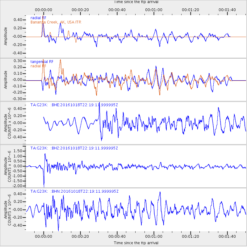
Signal To Noise
| Channel | StoN | STA | LTA |
| TA:G23K: :BHZ:20161018T22:19:11.999995Z | 5.812977 | 6.7599115E-7 | 1.1629002E-7 |
| TA:G23K: :BHN:20161018T22:19:11.999995Z | 1.8621677 | 1.5718298E-7 | 8.440861E-8 |
| TA:G23K: :BHE:20161018T22:19:11.999995Z | 2.3422606 | 2.5194012E-7 | 1.075628E-7 |
| Arrivals |
| Ps | |
| PpPs | |
| PsPs/PpSs | |


