You are here: Home > Network List > TA - USArray Transportable Network (new EarthScope stations) Stations List
> Station J25K Salcha River, AK, USA > Earthquake Result Viewer
J25K Salcha River, AK, USA - Earthquake Result Viewer
*The percent match for this event was below the threshold and hence no stack was calculated.
| Earthquake location: |
Leeward Islands |
| Earthquake latitude/longitude: |
15.2/-61.5 |
| Earthquake time(UTC): |
2016/10/18 (292) 22:08:14 GMT |
| Earthquake Depth: |
143 km |
| Earthquake Magnitude: |
5.6 MWW, 5.6 MWB |
| Earthquake Catalog/Contributor: |
NEIC PDE/NEIC COMCAT |
|
| Network: |
TA USArray Transportable Network (new EarthScope stations) |
| Station: |
J25K Salcha River, AK, USA |
| Lat/Lon: |
64.61 N/145.37 W |
| Elevation: |
949 m |
|
| Distance: |
73.7 deg |
| Az: |
333.482 deg |
| Baz: |
88.852 deg |
| Ray Param: |
$rayparam |
*The percent match for this event was below the threshold and hence was not used in the summary stack. |
|
| Radial Match: |
65.6074 % |
| Radial Bump: |
400 |
| Transverse Match: |
52.709255 % |
| Transverse Bump: |
400 |
| SOD ConfigId: |
11737051 |
| Insert Time: |
2019-04-25 19:57:33.201 +0000 |
| GWidth: |
2.5 |
| Max Bumps: |
400 |
| Tol: |
0.001 |
|
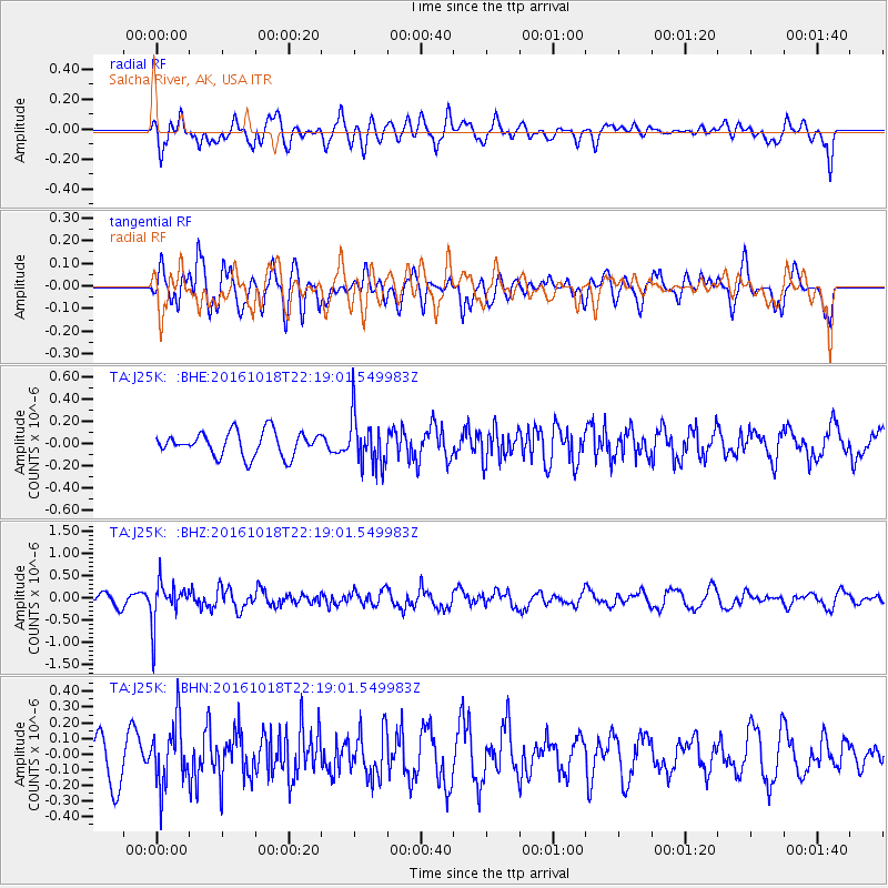
Signal To Noise
| Channel | StoN | STA | LTA |
| TA:J25K: :BHZ:20161018T22:19:01.549983Z | 3.786242 | 4.6161696E-7 | 1.2191956E-7 |
| TA:J25K: :BHN:20161018T22:19:01.549983Z | 1.2794247 | 1.9537907E-7 | 1.5270854E-7 |
| TA:J25K: :BHE:20161018T22:19:01.549983Z | 2.029554 | 2.2217053E-7 | 1.0946767E-7 |
| Arrivals |
| Ps | |
| PpPs | |
| PsPs/PpSs | |


