You are here: Home > Network List > TA - USArray Transportable Network (new EarthScope stations) Stations List
> Station L19K White Mountain, AK, USA > Earthquake Result Viewer
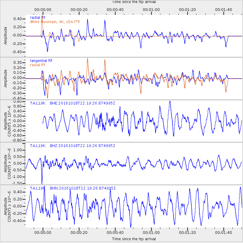
L19K White Mountain, AK, USA - Earthquake Result Viewer
*The percent match for this event was below the threshold and hence no stack was calculated.
| Earthquake location: |
Leeward Islands |
| Earthquake latitude/longitude: |
15.2/-61.5 |
| Earthquake time(UTC): |
2016/10/18 (292) 22:08:14 GMT |
| Earthquake Depth: |
143 km |
| Earthquake Magnitude: |
5.6 MWW, 5.6 MWB |
| Earthquake Catalog/Contributor: |
NEIC PDE/NEIC COMCAT |
|
| Network: |
TA USArray Transportable Network (new EarthScope stations) |
| Station: |
L19K White Mountain, AK, USA |
| Lat/Lon: |
62.18 N/154.85 W |
| Elevation: |
650 m |
|
| Distance: |
78.2 deg |
| Az: |
331.419 deg |
| Baz: |
79.876 deg |
| Ray Param: |
$rayparam |
*The percent match for this event was below the threshold and hence was not used in the summary stack. |
|
| Radial Match: |
45.935238 % |
| Radial Bump: |
400 |
| Transverse Match: |
64.70494 % |
| Transverse Bump: |
400 |
| SOD ConfigId: |
11737051 |
| Insert Time: |
2019-04-25 19:57:40.735 +0000 |
| GWidth: |
2.5 |
| Max Bumps: |
400 |
| Tol: |
0.001 |
|
Signal To Noise
| Channel | StoN | STA | LTA |
| TA:L19K: :BHZ:20161018T22:19:26.874995Z | 1.8968381 | 4.0542798E-7 | 2.1373884E-7 |
| TA:L19K: :BHN:20161018T22:19:26.874995Z | 0.78818417 | 2.1257104E-7 | 2.6969718E-7 |
| TA:L19K: :BHE:20161018T22:19:26.874995Z | 0.82695115 | 1.9451664E-7 | 2.3522144E-7 |
| Arrivals |
| Ps | |
| PpPs | |
| PsPs/PpSs | |


