You are here: Home > Network List > TA - USArray Transportable Network (new EarthScope stations) Stations List
> Station MDND Maddock, ND, USA > Earthquake Result Viewer
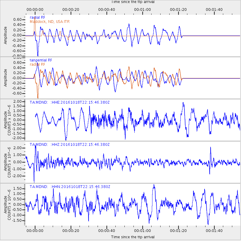
MDND Maddock, ND, USA - Earthquake Result Viewer
*The percent match for this event was below the threshold and hence no stack was calculated.
| Earthquake location: |
Leeward Islands |
| Earthquake latitude/longitude: |
15.2/-61.5 |
| Earthquake time(UTC): |
2016/10/18 (292) 22:08:14 GMT |
| Earthquake Depth: |
143 km |
| Earthquake Magnitude: |
5.6 MWW, 5.6 MWB |
| Earthquake Catalog/Contributor: |
NEIC PDE/NEIC COMCAT |
|
| Network: |
TA USArray Transportable Network (new EarthScope stations) |
| Station: |
MDND Maddock, ND, USA |
| Lat/Lon: |
47.85 N/99.60 W |
| Elevation: |
479 m |
|
| Distance: |
45.2 deg |
| Az: |
324.155 deg |
| Baz: |
122.938 deg |
| Ray Param: |
$rayparam |
*The percent match for this event was below the threshold and hence was not used in the summary stack. |
|
| Radial Match: |
70.7656 % |
| Radial Bump: |
400 |
| Transverse Match: |
53.323494 % |
| Transverse Bump: |
400 |
| SOD ConfigId: |
11737051 |
| Insert Time: |
2019-04-25 19:57:54.960 +0000 |
| GWidth: |
2.5 |
| Max Bumps: |
400 |
| Tol: |
0.001 |
|
Signal To Noise
| Channel | StoN | STA | LTA |
| TA:MDND: :HHZ:20161018T22:15:46.380Z | 2.3647337 | 1.0626406E-6 | 4.4937013E-7 |
| TA:MDND: :HHN:20161018T22:15:46.380Z | 0.86936826 | 5.52394E-7 | 6.3539704E-7 |
| TA:MDND: :HHE:20161018T22:15:46.380Z | 0.7732307 | 5.626114E-7 | 7.276113E-7 |
| Arrivals |
| Ps | |
| PpPs | |
| PsPs/PpSs | |


