You are here: Home > Network List > TA - USArray Transportable Network (new EarthScope stations) Stations List
> Station MSTX Muleshoe, TX, USA > Earthquake Result Viewer
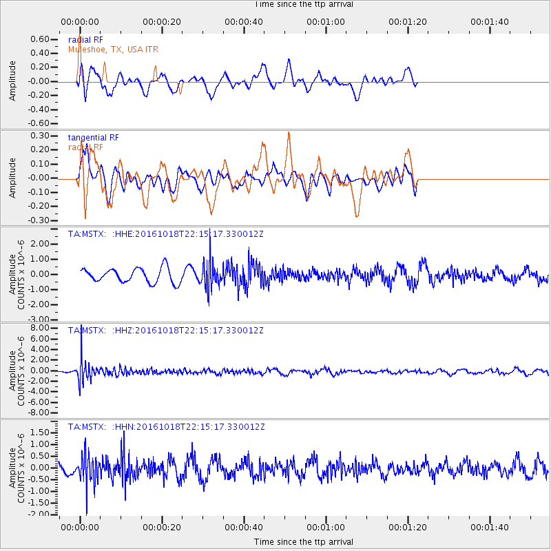
MSTX Muleshoe, TX, USA - Earthquake Result Viewer
*The percent match for this event was below the threshold and hence no stack was calculated.
| Earthquake location: |
Leeward Islands |
| Earthquake latitude/longitude: |
15.2/-61.5 |
| Earthquake time(UTC): |
2016/10/18 (292) 22:08:14 GMT |
| Earthquake Depth: |
143 km |
| Earthquake Magnitude: |
5.6 MWW, 5.6 MWB |
| Earthquake Catalog/Contributor: |
NEIC PDE/NEIC COMCAT |
|
| Network: |
TA USArray Transportable Network (new EarthScope stations) |
| Station: |
MSTX Muleshoe, TX, USA |
| Lat/Lon: |
33.97 N/102.77 W |
| Elevation: |
1167 m |
|
| Distance: |
41.6 deg |
| Az: |
304.3 deg |
| Baz: |
106.348 deg |
| Ray Param: |
$rayparam |
*The percent match for this event was below the threshold and hence was not used in the summary stack. |
|
| Radial Match: |
59.100464 % |
| Radial Bump: |
351 |
| Transverse Match: |
49.526405 % |
| Transverse Bump: |
400 |
| SOD ConfigId: |
11737051 |
| Insert Time: |
2019-04-25 19:58:00.623 +0000 |
| GWidth: |
2.5 |
| Max Bumps: |
400 |
| Tol: |
0.001 |
|
Signal To Noise
| Channel | StoN | STA | LTA |
| TA:MSTX: :HHZ:20161018T22:15:17.330012Z | 10.372123 | 2.048016E-6 | 1.974539E-7 |
| TA:MSTX: :HHN:20161018T22:15:17.330012Z | 3.5270867 | 5.9199374E-7 | 1.6784213E-7 |
| TA:MSTX: :HHE:20161018T22:15:17.330012Z | 1.8365347 | 8.566934E-7 | 4.6647276E-7 |
| Arrivals |
| Ps | |
| PpPs | |
| PsPs/PpSs | |


