You are here: Home > Network List > TA - USArray Transportable Network (new EarthScope stations) Stations List
> Station R11A Troy Canyon, Currant, NV, USA > Earthquake Result Viewer
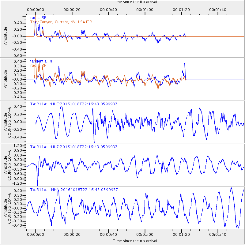
R11A Troy Canyon, Currant, NV, USA - Earthquake Result Viewer
*The percent match for this event was below the threshold and hence no stack was calculated.
| Earthquake location: |
Leeward Islands |
| Earthquake latitude/longitude: |
15.2/-61.5 |
| Earthquake time(UTC): |
2016/10/18 (292) 22:08:14 GMT |
| Earthquake Depth: |
143 km |
| Earthquake Magnitude: |
5.6 MWW, 5.6 MWB |
| Earthquake Catalog/Contributor: |
NEIC PDE/NEIC COMCAT |
|
| Network: |
TA USArray Transportable Network (new EarthScope stations) |
| Station: |
R11A Troy Canyon, Currant, NV, USA |
| Lat/Lon: |
38.35 N/115.59 W |
| Elevation: |
1756 m |
|
| Distance: |
52.7 deg |
| Az: |
306.787 deg |
| Baz: |
100.495 deg |
| Ray Param: |
$rayparam |
*The percent match for this event was below the threshold and hence was not used in the summary stack. |
|
| Radial Match: |
59.012783 % |
| Radial Bump: |
400 |
| Transverse Match: |
68.905624 % |
| Transverse Bump: |
400 |
| SOD ConfigId: |
11737051 |
| Insert Time: |
2019-04-25 19:58:22.388 +0000 |
| GWidth: |
2.5 |
| Max Bumps: |
400 |
| Tol: |
0.001 |
|
Signal To Noise
| Channel | StoN | STA | LTA |
| TA:R11A: :HHZ:20161018T22:16:43.059993Z | 5.5431514 | 4.3136257E-7 | 7.781901E-8 |
| TA:R11A: :HHN:20161018T22:16:43.059993Z | 1.0146941 | 9.914703E-8 | 9.771125E-8 |
| TA:R11A: :HHE:20161018T22:16:43.059993Z | 1.0055368 | 2.2178992E-7 | 2.2056868E-7 |
| Arrivals |
| Ps | |
| PpPs | |
| PsPs/PpSs | |


