You are here: Home > Network List > TA - USArray Transportable Network (new EarthScope stations) Stations List
> Station TUL1 Leonard, OK, USA > Earthquake Result Viewer
TUL1 Leonard, OK, USA - Earthquake Result Viewer
*The percent match for this event was below the threshold and hence no stack was calculated.
| Earthquake location: |
Leeward Islands |
| Earthquake latitude/longitude: |
15.2/-61.5 |
| Earthquake time(UTC): |
2016/10/18 (292) 22:08:14 GMT |
| Earthquake Depth: |
143 km |
| Earthquake Magnitude: |
5.6 MWW, 5.6 MWB |
| Earthquake Catalog/Contributor: |
NEIC PDE/NEIC COMCAT |
|
| Network: |
TA USArray Transportable Network (new EarthScope stations) |
| Station: |
TUL1 Leonard, OK, USA |
| Lat/Lon: |
35.91 N/95.79 W |
| Elevation: |
256 m |
|
| Distance: |
36.9 deg |
| Az: |
310.365 deg |
| Baz: |
115.037 deg |
| Ray Param: |
$rayparam |
*The percent match for this event was below the threshold and hence was not used in the summary stack. |
|
| Radial Match: |
73.638405 % |
| Radial Bump: |
400 |
| Transverse Match: |
72.84389 % |
| Transverse Bump: |
400 |
| SOD ConfigId: |
11737051 |
| Insert Time: |
2019-04-25 19:58:36.496 +0000 |
| GWidth: |
2.5 |
| Max Bumps: |
400 |
| Tol: |
0.001 |
|
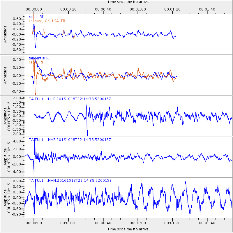
Signal To Noise
| Channel | StoN | STA | LTA |
| TA:TUL1: :HHZ:20161018T22:14:38.520015Z | 5.8377867 | 1.4307443E-6 | 2.4508336E-7 |
| TA:TUL1: :HHN:20161018T22:14:38.520015Z | 1.4897057 | 3.7326174E-7 | 2.5056073E-7 |
| TA:TUL1: :HHE:20161018T22:14:38.520015Z | 2.1846018 | 6.912163E-7 | 3.1640383E-7 |
| Arrivals |
| Ps | |
| PpPs | |
| PsPs/PpSs | |


