You are here: Home > Network List > TA - USArray Transportable Network (new EarthScope stations) Stations List
> Station WHTX Lake Whitney, Meridian, TX, USA > Earthquake Result Viewer
WHTX Lake Whitney, Meridian, TX, USA - Earthquake Result Viewer
*The percent match for this event was below the threshold and hence no stack was calculated.
| Earthquake location: |
Leeward Islands |
| Earthquake latitude/longitude: |
15.2/-61.5 |
| Earthquake time(UTC): |
2016/10/18 (292) 22:08:14 GMT |
| Earthquake Depth: |
143 km |
| Earthquake Magnitude: |
5.6 MWW, 5.6 MWB |
| Earthquake Catalog/Contributor: |
NEIC PDE/NEIC COMCAT |
|
| Network: |
TA USArray Transportable Network (new EarthScope stations) |
| Station: |
WHTX Lake Whitney, Meridian, TX, USA |
| Lat/Lon: |
31.99 N/97.46 W |
| Elevation: |
190 m |
|
| Distance: |
36.7 deg |
| Az: |
303.444 deg |
| Baz: |
108.566 deg |
| Ray Param: |
$rayparam |
*The percent match for this event was below the threshold and hence was not used in the summary stack. |
|
| Radial Match: |
54.375446 % |
| Radial Bump: |
400 |
| Transverse Match: |
44.93342 % |
| Transverse Bump: |
400 |
| SOD ConfigId: |
11737051 |
| Insert Time: |
2019-04-25 19:58:41.174 +0000 |
| GWidth: |
2.5 |
| Max Bumps: |
400 |
| Tol: |
0.001 |
|
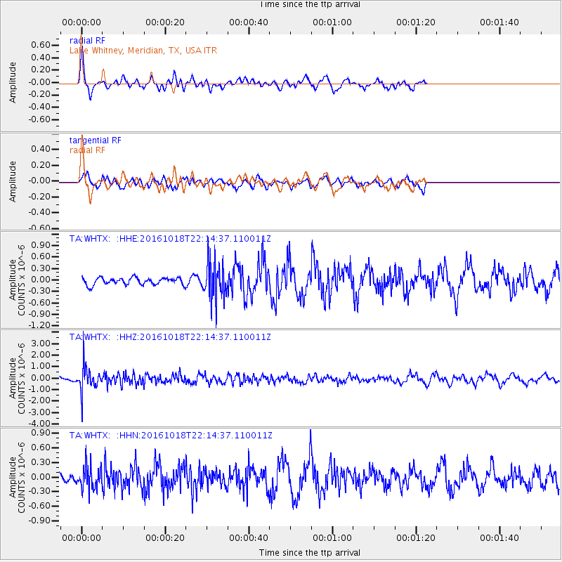
Signal To Noise
| Channel | StoN | STA | LTA |
| TA:WHTX: :HHZ:20161018T22:14:37.110011Z | 6.27928 | 1.0956909E-6 | 1.7449307E-7 |
| TA:WHTX: :HHN:20161018T22:14:37.110011Z | 1.4357339 | 2.4349205E-7 | 1.6959413E-7 |
| TA:WHTX: :HHE:20161018T22:14:37.110011Z | 5.216137 | 4.833125E-7 | 9.265716E-8 |
| Arrivals |
| Ps | |
| PpPs | |
| PsPs/PpSs | |


