You are here: Home > Network List > UW - Pacific Northwest Regional Seismic Network Stations List
> Station PASS Maple Falls, WA, USA > Earthquake Result Viewer
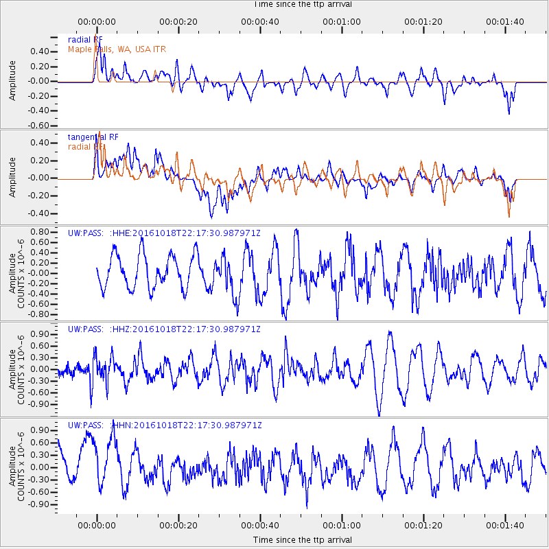
PASS Maple Falls, WA, USA - Earthquake Result Viewer
*The percent match for this event was below the threshold and hence no stack was calculated.
| Earthquake location: |
Leeward Islands |
| Earthquake latitude/longitude: |
15.2/-61.5 |
| Earthquake time(UTC): |
2016/10/18 (292) 22:08:14 GMT |
| Earthquake Depth: |
143 km |
| Earthquake Magnitude: |
5.6 MWW, 5.6 MWB |
| Earthquake Catalog/Contributor: |
NEIC PDE/NEIC COMCAT |
|
| Network: |
UW Pacific Northwest Regional Seismic Network |
| Station: |
PASS Maple Falls, WA, USA |
| Lat/Lon: |
49.00 N/122.09 W |
| Elevation: |
174 m |
|
| Distance: |
59.4 deg |
| Az: |
318.219 deg |
| Baz: |
102.414 deg |
| Ray Param: |
$rayparam |
*The percent match for this event was below the threshold and hence was not used in the summary stack. |
|
| Radial Match: |
51.60457 % |
| Radial Bump: |
400 |
| Transverse Match: |
51.872944 % |
| Transverse Bump: |
400 |
| SOD ConfigId: |
11737051 |
| Insert Time: |
2019-04-25 19:59:36.769 +0000 |
| GWidth: |
2.5 |
| Max Bumps: |
400 |
| Tol: |
0.001 |
|
Signal To Noise
| Channel | StoN | STA | LTA |
| UW:PASS: :HHZ:20161018T22:17:30.987971Z | 1.1603729 | 3.319973E-7 | 2.861126E-7 |
| UW:PASS: :HHN:20161018T22:17:30.987971Z | 2.0615134 | 6.897028E-7 | 3.345614E-7 |
| UW:PASS: :HHE:20161018T22:17:30.987971Z | 1.268094 | 4.051632E-7 | 3.195057E-7 |
| Arrivals |
| Ps | |
| PpPs | |
| PsPs/PpSs | |


