You are here: Home > Network List > MM - Myanmar National Seismic Network Stations List
> Station TMU Tamu, Sagaing, Myanmar > Earthquake Result Viewer
TMU Tamu, Sagaing, Myanmar - Earthquake Result Viewer
| Earthquake location: |
Java Sea |
| Earthquake latitude/longitude: |
-4.9/108.2 |
| Earthquake time(UTC): |
2016/10/19 (293) 00:26:01 GMT |
| Earthquake Depth: |
614 km |
| Earthquake Magnitude: |
6.6 MWW, 6.6 MWC, 6.7 MWB |
| Earthquake Catalog/Contributor: |
NEIC PDE/NEIC COMCAT |
|
| Network: |
MM Myanmar National Seismic Network |
| Station: |
TMU Tamu, Sagaing, Myanmar |
| Lat/Lon: |
24.23 N/94.30 E |
| Elevation: |
182 m |
|
| Distance: |
31.9 deg |
| Az: |
335.56 deg |
| Baz: |
153.154 deg |
| Ray Param: |
0.07590729 |
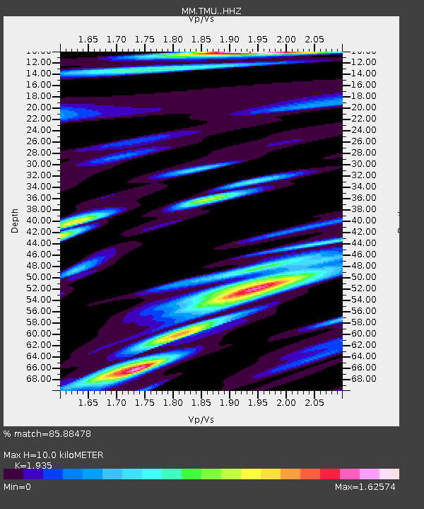
| Estimated Moho Depth: |
10.0 km |
| Estimated Crust Vp/Vs: |
1.93 |
| Assumed Crust Vp: |
6.316 km/s |
| Estimated Crust Vs: |
3.264 km/s |
| Estimated Crust Poisson's Ratio: |
0.32 |
|
| Radial Match: |
85.88478 % |
| Radial Bump: |
400 |
| Transverse Match: |
79.62141 % |
| Transverse Bump: |
400 |
| SOD ConfigId: |
11737051 |
| Insert Time: |
2019-04-25 20:10:01.560 +0000 |
| GWidth: |
2.5 |
| Max Bumps: |
400 |
| Tol: |
0.001 |
|

Signal To Noise
| Channel | StoN | STA | LTA |
| MM:TMU: :HHZ:20161019T00:31:07.937992Z | 32.856045 | 1.3740319E-5 | 4.1819763E-7 |
| MM:TMU: :HHN:20161019T00:31:07.937992Z | 52.92735 | 1.28121965E-5 | 2.4207137E-7 |
| MM:TMU: :HHE:20161019T00:31:07.937992Z | 39.406418 | 5.7661873E-6 | 1.463261E-7 |
| Arrivals |
| Ps | 1.6 SECOND |
| PpPs | 4.4 SECOND |
| PsPs/PpSs | 5.9 SECOND |


